Sebastopol, New South Wales
Town in New South Wales, Australia
34°34′48″S 147°31′03″E / 34.58000°S 147.51750°E / -34.58000; 147.51750- 15 km (9 mi) from Temora
- 19 km (12 mi) from Junee Reefs
Sebastopol is a village community in the north east part of the Riverina, in New South Wales, Australia. It is situated about 15 kilometres south of Temora and 19 kilometres north of Junee Reefs.
It was named after Sevastopol, the site of an important battle during the Crimean War. Gold was mined there from c. 1870.[2] Sebastopol Post Office opened on 7 March 1870 and closed in 1973.[3] Sebastopol had a school from 1871 to 1949.[4]
Near Sebastopol is the 248 hectare site of a 90 Mega-Watt solar farm that became operational in December 2021.[5][6]
-
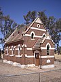 St Stephen's Church Sebastopol
 -
 Ruins at Sebastopol


Notes and references
- ^ Australian Bureau of Statistics (28 June 2022). "Sebastopol (NSW) (suburb and locality)". Australian Census 2021 QuickStats. Retrieved 28 June 2022.

- ^ "Sebastopol Reefs". Sydney Mail (NSW : 1860 - 1871). 30 April 1870. p. 9. Retrieved 5 March 2021.
- ^ Premier Postal History, Post Office List, retrieved 11 June 2009
- ^ "Sebastopol". nswgovschoolhistory.cese.nsw.gov.au. Retrieved 5 March 2021.
- ^ "Home". FRV Sebastopol Solar Farm. Retrieved 4 December 2022.
- ^ "NSW's Sebastopol Solar Farm up and running". pv magazine Australia. Retrieved 4 December 2022.
Wikimedia Commons has media related to Sebastopol, New South Wales.
- v
- t
- e

Communities
- Adelong
- Adjungbilly
- Alfredtown
- Alma Park
- Ardlethan
- Ariah Park
- Ballbank
- Balldale
- Balranald
- Barellan
- Barham
- Barnes
- Barooga
- Batlow
- Beckom
- Bectric
- Beelbangera
- Beggan Beggan
- Berrigan
- Bethungra
- Bidgeemia
- Bilbul
- Binya
- Birrego
- Blighty
- Book Book
- Bookham
- Booligal
- Booroorban
- Borambola
- Boree Creek
- Bowna
- Brawlin
- Brocklesby
- Brookdale
- Brungle
- Brushwood
- Bulgandry
- Bullenbung
- Bundure
- Bungowannah
- Bunnaloo
- Buraja
- Burraboi
- Burrandana
- Burrinjuck
- Burrumbuttock
- Caldwell
- Carabost
- Carrathool
- Cavan
- Coleambally
- Collingullie
- Colinroobie
- Combaning
- Conargo
- Condoulpe
- Cookardinia
- Coolac
- Coolamon
- Cootamundra
- Coree
- Coreen
- Corobimilla
- Corowa
- Cowabbie
- Culcairn
- Cunninyeuk
- Currawarna
- Darbalara
- Darlington Point
- Daysdale
- Deniliquin
- Dilpurra
- Dirnaseer
- Downside
- Euberta
- Eurongilly
- Euston
- Ferndale
- Finley
- Frampton
- French Park
- Galore
- Ganmain
- Gidginbung
- Gerogery
- Gobarralong
- Gocup
- Gogeldrie
- Goolgowi
- Goorawin
- Grahamstown
- Greenvale
- Grong Grong
- Gulpa
- Gunbar
- Gundagai
- Hanwood
- Harefield
- Hay
- Henty
- Hillston
- Holbrook
- Hopefield
- Howlong
- Humula
- Illabo
- Illilawa
- Jerilderie
- Jindera
- Jingellic
- Jugiong
- Junee
- Junee Reefs
- Kamarah
- Khancoban
- Koraleigh
- Kyalite
- Kyeamba
- Kywong
- Lacmalac
- Ladysmith
- Langtree
- Lankeys Creek
- Laurel Hill
- Leeton
- Little Billabong
- Lockhart
- Logie Brae
- Lowesdale
- Mairjimmy
- Malebo
- Mangoplah
- Mannus
- Marinna
- Marrar
- Mathoura
- Matong
- Maude
- Mayrung
- Merriwagga
- Merungle Hill
- Methul
- Milbrulong
- Millwood
- Mirrool
- Mitta Mitta
- Moama
- Moira
- Moolpa
- Moombooldool
- Morago
- Morundah
- Morven
- Moulamein
- Mullengandra
- Mulwala
- Mundarlo
- Munderoo
- Murrami
- Muttama
- Nangus
- Narraburra
- Narrandera
- Niemur
- Nyora
- Oaklands
- Oberne
- Old Junee
- One Tree
- Osborne
- Oura
- Ournie
- Oxley
- Penarie
- Perekerten
- Pleasant Hills
- Pretty Pine
- Pulletop
- Rand
- Rankins Springs
- Rannock
- Rennie
- Rosewood
- Ryan
- Sandigo
- Sangar
- Savernake
- Sebastopol
- Speewa
- Springdale
- Stanbridge
- Stockinbingal
- Stony Crossing
- Stony Point
- Tabbita
- Table Top
- Talbingo
- Talmalmo
- Talmo
- Tantonan
- Tarcutta
- Temora
- The Rock
- Tocumwal
- Tooleybuc
- Tooma
- Tootool
- Tullakool
- Tumbarumba
- Tumblong
- Tumut
- Tuppal
- Urana
- Urangeline
- Urangeline East
- Uranquinty
- Waddi
- Wakool
- Walbundrie
- Walla Walla
- Wallendbeen
- Walleroobie
- Wamoon
- Wanganella
- Wantabadgery
- Warburn
- Warragoon
- Wee Jasper
- Welaregang
- Westby
- Whitton
- Widgelli
- Widgiewa
- Willbriggie
- Womboota
- Wondalga
- Woodend
- Woolgarlo
- Woomargama
- Wymah
- Yalgogrin South
- Yallakool
- Yanco
- Yenda
- Yerong Creek
- Yoogali
- Yuluma
- Cocoparra
- Lachlan Valley
- Livingstone
- Murray Valley
- Murrumbidgee Valley
- Oolambeyan
- Woomargama
- Yanga
Water and irrigation entities
Other watercourses
- Darling
- Edward
- Goodradigbee
- Lachlan
- Little Murray
- Murray
- Murrumbidgee
- Niemur
- Paddys
- Rufus
- Tooma
- Tumut
- Wakool
- Yass
- Murray Irrigation Area
- Murrumbidgee Irrigation Area
- Murrumbidgee Irrigation
- Riverina Water County Council
- Adelong
- Adjungbilly
- Back
- Barmedman
- Bendy
- Berthong
- Billabong
- Black Joes
- Bland
- Bowning
- Broadway
- Brooks
- Bulls Head
- Bungendore
- Burkes
- Cohen
- Dairy
- Derringullen
- Gum Flat
- Hell Hole
- Little
- Jerra Jerra
- Kindra
- Mannus
- Maragle
- Mirrool
- Mulwala Canal
- Murrumbateman
- Peelwood
- Pugilistic
- Reedy
- Sandy (Mirrool)
- Spring
- Tarcutta
- Taylors
- Tumbarumba
- Yellow Bog


