Perisher Valley, New South Wales
Human settlement in New South Wales, Australia
Perisher Valley, commonly called Perisher, is a valley formed below Mount Perisher, a mountain that is located in the Snowy Mountains of New South Wales, Australia.
Located in the Snowy Monaro Regional Council, the valley is the site of one of four resort bases of the Perisher Ski Resort, which also comprises Guthega, Blue Cow and Smiggin Holes. It is located within the Kosciuszko National Park between Jindabyne and Charlotte Pass on the Kosciuszko Road. Access to the valley is via the Skitube Alpine Railway or by road. Although it is primarily a winter only resort village, year round accommodations are available, including tours, and bush walks.[1]
At the 2021 census, Perisher Valley had a population of 99 people.[2] In winter, the population is approximately 2,500 due to guests.
Climate
Perisher Valley has a subpolar oceanic (Köppen Cfc) with cool, sunny summers accompanied by cold minimum temperatures; wet, snowy springs, and cold, very snowy winters. As expected of a ski resort there is a snowpack lasting for several months of the year, sometimes into early summer, however not as long-lasting as equivalent or even lower elevations over the western side of the range due to its sheltered location. Snow can be expected to fall on 60.2 days of the year on average.[3]
| Climate data for Perisher Valley (1976–2010); 1,735 m AMSL; 36.40° S, 148.41° E | |||||||||||||
|---|---|---|---|---|---|---|---|---|---|---|---|---|---|
| Month | Jan | Feb | Mar | Apr | May | Jun | Jul | Aug | Sep | Oct | Nov | Dec | Year |
| Record high °C (°F) | 30.3 (86.5) | 29.8 (85.6) | 25.4 (77.7) | 22.0 (71.6) | 18.0 (64.4) | 14.0 (57.2) | 10.5 (50.9) | 13.5 (56.3) | 16.0 (60.8) | 21.0 (69.8) | 25.5 (77.9) | 25.2 (77.4) | 30.3 (86.5) |
| Mean daily maximum °C (°F) | 19.2 (66.6) | 18.5 (65.3) | 15.7 (60.3) | 11.7 (53.1) | 7.9 (46.2) | 3.9 (39.0) | 2.4 (36.3) | 3.4 (38.1) | 5.8 (42.4) | 9.7 (49.5) | 13.9 (57.0) | 15.9 (60.6) | 10.7 (51.2) |
| Mean daily minimum °C (°F) | 5.8 (42.4) | 5.3 (41.5) | 3.3 (37.9) | 0.3 (32.5) | −1.5 (29.3) | −3.5 (25.7) | −5.0 (23.0) | −4.3 (24.3) | −2.0 (28.4) | 0.2 (32.4) | 2.0 (35.6) | 3.8 (38.8) | 0.4 (32.7) |
| Record low °C (°F) | −5.0 (23.0) | −7.0 (19.4) | −7.0 (19.4) | −9.8 (14.4) | −11.3 (11.7) | −18.0 (−0.4) | −19.5 (−3.1) | −15.0 (5.0) | −12.5 (9.5) | −11.6 (11.1) | −8.5 (16.7) | −7.0 (19.4) | −19.5 (−3.1) |
| Average precipitation mm (inches) | 96.8 (3.81) | 73.1 (2.88) | 114.5 (4.51) | 97.5 (3.84) | 130.9 (5.15) | 167.8 (6.61) | 186.1 (7.33) | 240.7 (9.48) | 234.0 (9.21) | 182.1 (7.17) | 138.5 (5.45) | 95.3 (3.75) | 1,764.6 (69.47) |
| Average precipitation days | 7.8 | 7.8 | 9.4 | 10.0 | 11.7 | 13.3 | 13.3 | 13.9 | 14.3 | 13.0 | 11.5 | 8.0 | 134.0 |
| Source: [4] | |||||||||||||
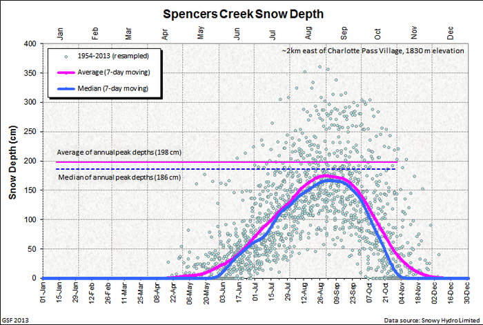
Snow depth
Snow depth measurements are taken by Snowy Hydro at Spencers Creek, approximately 2 kilometres (1 mi) west of Perisher Valley.

History

The Snowy Mountains region is thought to have had Aboriginal occupation for some twenty thousand years. Large scale intertribal gatherings were held in the High Country during summer for collective feasting on the Bogong moth.
This practice continued until around 1865.[5] European explorers entered the district from 1835, and in 1840, Edmund Strzelecki ascended Mount Kosciuszko and named it after a Polish patriot. High country stockmen followed who used the Snowy Mountains for grazing during the summer months. Banjo Paterson's famous poem The Man From Snowy River recalls this era. The cattle graziers have left a legacy of mountain huts scattered across the area.[6] A story, which may be apocryphal, credits James Spencer, who settled in the area in the 1840s with saying 'What a perisher' when caught in a storm, giving origin to the Perisher area.[7]
The Kosciuszko National Park in which Perisher is situated came into existence as the National Chase Snowy Mountains on 5 December 1906. In 1944 this became the Kosciuszko State Park, and then the Kosciuszko National Park in 1967.[8]

The development of Skiing in Australia began at Kiandra in the Northern Snowy Mountains around 1861, but in the 20th century, the focus of Skiing in New South Wales shifted towards the Mount Kosciuszko region. The first Kosciuszko Chalet was built at Charlotte Pass in 1930, giving relatively comfortable access to Australia's highest terrain.[9] The growing number of ski enthusiasts heading to Charlotte Pass led to the establishment of a cafe at Smiggin Holes, near Perisher Valley, around 1939, where horse-drawn sleighs would deliver skiers to be begin the arduous ski to the Kosciusko Chalet.[10] It was the construction of the vast Snowy Mountains Hydro-Electric Scheme from 1949 that really opened up the Snowy Mountains for large scale development of a ski industry and led to the establishment of Thredbo and Perisher as leading Australian resorts.[11][12] The Construction of Guthega Dam brought skiers to the isolated Guthega district and a rope tow was installed there in 1957.[13]
As the number of skiers increased, services, facilities and means of access were improved, and Perisher's first lodges were constructed. Telemark and the Snow Revellers Club being completed in 1952. In the winter of 1953 the first oversnow transport operated to Perisher Valley. It was greeted by the inhabitants with cheers and celebrations. In 1958, Svere Kaaten, another pioneer of the mountains, built a sophisticated rope tow at North Perisher. Ken Murray, an old friend of Svere's built another rope tow and Perisher's first T-bar. Development continued and Mount Perisher Double Chair was opened in 1962. After the opening of the first chairlift, T-bar expansion and rope tows, the Perisher area thrived. Murray Publishers Pty Limited was taken over by Australian Consolidated Press in 1972 and Kosciuszko Alpine Resorts was formed. Murray Publishers then traded under the name of Perisher Ski Resort which incorporated the resorts of Perisher and Smiggins. In 1995, Murray Publishers Pty Limited and the Alpine Australia Group Pty Limited merged to form Perisher Blue Pty Limited.[citation needed]
The last establishment of a major skifield in NSW came with the development of Mount Blue Cow in the 1980s. In 1987 the Swiss designed Skitube Alpine Railway opened to deliver skiers from Bullocks Flat, on the Alpine Way, to Perisher Valley and to Blue Cow, which also opened in 1987.[12] The operators of Blue Cow purchased Guthega in 1991, and the new combined resort later merged with Perisher-Smiggins to become the largest ski resort in the Southern Hemisphere.[14] In 2009 Perisher had 48 lifts covering 1,245 hectares and four village base areas: Perisher Valley, Blue Cow, Smiggin Holes and Guthega.[15]
Snowy Mountains of Music
Since 2009, Perisher Valley has been the host of the Snowy Mountains of Music Festival, a folk festival created by the same people behind the Illawarra Folk Festival. The festival runs every year on the Queen's Birthday Weekend, which is also the official start of the Ski Season for the Snowy Mountains. It acts as both a promotional festival for the Australian Snow Season, specifically, Perisher Valley, but also as an outlet for all sorts of Australian and International talent across a diverse range of genres. [16]
Resort statistics


Perisher Valley is situated at 1,720 metres (5,640 ft) above sea level. The summit of Mount Perisher above the village reaches 2,054 metres (6,739 ft) of altitude. The highest lifted point is the Mt Perisher Double Chair at 2034m. According to statistics posted on the Perisher website in 2012, the recognised natural snow line in the region is at 1,650 metres (5,410 ft) and over the previous 15 years, the average maximum snow depth throughout the Resort had been about 1.9 metres (6.2 ft). Average minimum temperature during winter was stated as −3.7 °C (25.3 °F).[17]
In 2012, the four resort bases of the Perisher Ski Resort contained a skiable area of 1,245 hectares (3,076 acres) and were serviced by 47 lifts, making Perisher the largest Australian ski resort.[17]
Gallery
-
 Olympic Ski Trail, leading to Perisher Valley from Back Perisher Mountain
 -
 A creek in Perisher
 -
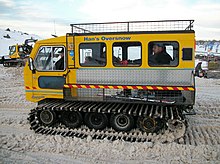
 A snow grooming machine in Perisher
 -
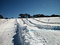 Toboggan field at Perisher
 -
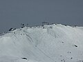
 Looking towards Blue Cow from Perisher


See also
 New South Wales portal
 Mountains portal


References
- ^ "Perisher Valley NSW - Accommodation, Skiing & Things to Do". VisitNSW.com. Retrieved 12 April 2016.
- ^ Australian Bureau of Statistics (28 June 2022). "Perisher Valley (Suburb/Locality)". 2021 Census QuickStats. Retrieved 17 August 2022.

- ^ Annual snow days sorted in descending order of average occurrence by australianweathernews.com
- ^ "Climate Statistics for Australian Locations - Perisher Valley Ski Centre". June 2011. Retrieved 13 November 2009.
- ^ "Kiandra Historical Society". Kiandrahistory.net. 10 February 1959. Retrieved 3 February 2016.
- ^ "Archived copy". Archived from the original on 13 May 2008. Retrieved 2 June 2011.
{{cite web}}: CS1 maint: archived copy as title (link) - ^ "Perisher Valley - Culture and History". The Sydney Morning Herald. 19 November 2008.
- ^ "Top of Australia hosts park's centenary". ABC News. Archived from the original on 6 December 2006. Retrieved 16 January 2008.
- ^ [1] Archived March 10, 2011, at the Wayback Machine
- ^ [2] Archived August 28, 2008, at the Wayback Machine
- ^ "Winter Ski & Snowboard | Summer Biking & Hiking". Thredbo.com.au. Retrieved 3 February 2016.
- ^ a b [3] Archived September 23, 2010, at the Wayback Machine
- ^ "Guthega Ski Resort". Christiana Capital. Retrieved 3 February 2016.
- ^ [4] Archived April 12, 2010, at the Wayback Machine
- ^ [5] Archived March 24, 2010, at the Wayback Machine
- ^ [6] Archived April 2, 2011, at the Wayback Machine
- ^ a b "Resort Stats". Perisher.com.au. 5 October 2015. Retrieved 3 February 2016.
- v
- t
- e
Towns and localities in the Snowy Monaro Regional Council local government area
- Adaminaby
- Ando
- Anembo
- Anglers Reach
- Berridale
- Bibbenluke
- Billilingra
- Bombala
- Bredbo
- Bumbalong
- Bunyan
- Burra
- Cathcart
- Chakola
- Colinton
- Coolringdon
- Cooma
- Dairymans Plains
- Dalgety
- Dangelong
- Delegate
- Dry Plain
- Eucumbene
- Jerangle
- Jindabyne
- Jingera
- Kosciuszko National Park
- Michelago
- Nimmitabel
- Numeralla
- Old Adaminaby
- Pine Valley
- Rhine Falls
- Rock Flat
- Shannons Flat
- Springfield
- Tantangara
- Tinderry
- Wambrook
- Williamsdale
- Yaouk
Main Article: Local government areas of New South Wales
36°24′S 148°25′E / 36.400°S 148.417°E / -36.400; 148.417


