Mount Lemmon
Mountain in Arizona, United States


Mount Lemmon
Mount Lemmon, with a summit elevation of 9,159 feet (2,792 m),[1] is the highest point in the Santa Catalina Mountains. It is located in the Coronado National Forest north of Tucson, Arizona, United States. Mount Lemmon was named for botanist Sara Plummer Lemmon, who trekked to the top of the mountain with her husband and E. O. Stratton, a local rancher, by horse and foot in 1881.[4][5] Mount Lemmon is also known as Babad Do'ag, or Frog Mountain[6] to the Tohono O'odham.
Geography
Climate
Due to the elevation change from the bottom to the top, the summit of the mountain can be 20–30°F cooler than the base. It usually sees at least one snowfall during the winter months, making it a cool escape and popular tourist attraction for Tucson inhabitants.
Geology
Mount Lemmon is made up of Bolsa Quartzite, Dripping Spring Quartzite, and a local sandstone and conglomerate. The portions have been intruded by a Diabase Dike of the Apace Group.[7]
Summerhaven
Summerhaven is a small town near the top of the mountain. It is a summer residence for many, but there are some year-round residents. There are many small cabins, most of which were rebuilt after the Aspen Fire of July 2003.[8]
| Climate data for Mount Lemmon, Arizona (1958–2009) | |||||||||||||
|---|---|---|---|---|---|---|---|---|---|---|---|---|---|
| Month | Jan | Feb | Mar | Apr | May | Jun | Jul | Aug | Sep | Oct | Nov | Dec | Year |
| Record high °F (°C) | 65 (18) | 65 (18) | 68 (20) | 74 (23) | 82 (28) | 91 (33) | 89 (32) | 82 (28) | 81 (27) | 76 (24) | 71 (22) | 65 (18) | 91 (33) |
| Mean daily maximum °F (°C) | 49.2 (9.6) | 48.3 (9.1) | 52.9 (11.6) | 60.8 (16.0) | 69.1 (20.6) | 76.4 (24.7) | 76.5 (24.7) | 73.6 (23.1) | 70.4 (21.3) | 61.7 (16.5) | 56.3 (13.5) | 50.6 (10.3) | 62.2 (16.8) |
| Mean daily minimum °F (°C) | 22.8 (−5.1) | 21.8 (−5.7) | 25.7 (−3.5) | 31.7 (−0.2) | 36.6 (2.6) | 44.4 (6.9) | 49.8 (9.9) | 49.8 (9.9) | 45.1 (7.3) | 36.4 (2.4) | 29.7 (−1.3) | 24.3 (−4.3) | 34.8 (1.6) |
| Record low °F (°C) | −4 (−20) | −7 (−22) | −1 (−18) | 19 (−7) | 27 (−3) | 32 (0) | 39 (4) | 42 (6) | 31 (−1) | 20 (−7) | 4 (−16) | 4 (−16) | −7 (−22) |
| Average precipitation inches (mm) | 3.15 (80) | 1.69 (43) | 1.17 (30) | 0.50 (13) | 0.42 (11) | 0.62 (16) | 4.41 (112) | 7.00 (178) | 3.39 (86) | 3.04 (77) | 2.95 (75) | 2.60 (66) | 30.94 (787) |
| Average snowfall inches (cm) | 16.5 (42) | 20.4 (52) | 6.8 (17) | 2.0 (5.1) | 0 (0) | 0 (0) | 0 (0) | 0 (0) | 0 (0) | 2.0 (5.1) | 6.2 (16) | 11.0 (28) | 64.9 (165) |
| Average precipitation days | 5 | 5 | 5 | 3 | 2 | 2 | 10 | 11 | 5 | 3 | 3 | 5 | 59 |
| Mean monthly sunshine hours | 241 | 243 | 299 | 325 | 374 | 372 | 327 | 319 | 315 | 301 | 260 | 242 | 3,618 |
| Source: Western Region Climate Center [9] | |||||||||||||
Mount Lemmon Station Observatory
At the peak is the Mount Lemmon Observatory, which was formerly the site of a USAF radar base of the Air Defense Command,[10] and the building that formerly housed a military emergency radar tracking station for landing the Space Shuttle at White Sands Missile Range. Although the United States military had a presence on the mountain for several decades all their facilities have been abandoned and were given to the United States Forest Service. The area and buildings that makes up the Mount Lemmon Station Observatory are leased from the Forest Service by the University of Arizona. The telescopes on the mountain are still used for astronomical research today by organizations such as the Catalina Sky Survey, the Mount Lemmon Sky Center,[11] the University of Arizona Astronomy Camp program,[12] the University of Arizona, and the University of Minnesota. The educational resources at the top of the mountain make it a unique research and teaching destination.
Catalina Highway

The Catalina Highway, also called the Mount Lemmon Highway, as well as the Hitchcock Highway (after Frank Harris Hitchcock), runs up the Santa Catalina Mountains from the east side of Tucson up to Summerhaven, at the top of Mt. Lemmon. The beautiful, curving road is a favorite drive for tourists, for locals escaping summer's heat and cyclists, and has been recently designated as the Sky Island Parkway, part of the US National Scenic Byway system.[13]
2010 saw the inaugural running of the Mount Lemmon Marathon.[14]
Fees and permits
Catalina Highway charges tolls for parking, camping, and hiking. However, the tolls are only officially charged for people who are camping. Tolls for other events, such as hiking, parking, or grilling, are a part of the honor system. Park rangers will not check for toll payments unless someone is using the park campgrounds. Anyone wishing to sightsee or travel to Summerhaven are not subjected to paying tolls.[citation needed]

Back side
An unpaved road to the summit on the north side of Mount Lemmon starts in Oracle, which is on Arizona Route 77 north of Tucson. It offers a secondary route to the top. This route is popular with off-road 4x4 drivers and with off-road or dual-purpose motorcyclists. This road ends at the Catalina Highway near Loma Linda. Before the Catalina Highway was built it was the only route up the mountain.[15]
-
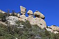 Hoodoos, Santa Catalina Mountains
 -
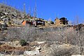
 Remnants of the 2003 Aspen Fire
 -
 Mount Lemmon Ski Valley
 -
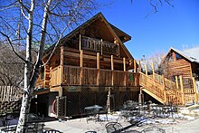
 Cabins atop Mt Lemmon in Summerhaven
 -
 View of the telescopes on Mount Lemmon
 -
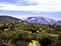 View of Mount Lemmon from Oracle, AZ
 -
 Unpaved road on the north or "backside" of Mount Lemmon
 -
 Catalina Highway climbing Mount Lemmon
 -
 Stereograph of the Mt Lemmon Highway near Windy Point Vista.


See also
- List of Ultras of the United States
- Mount Lemmon Observatory
- Mount Lemmon Ski Valley
- Mount Lemmon Survey
References
- ^ a b c "Catalina 2 Reset". NGS Data Sheet. National Geodetic Survey, National Oceanic and Atmospheric Administration, United States Department of Commerce. Retrieved August 18, 2016.
- ^ "Mount Lemmon, Arizona". Peakbagger.com. Retrieved February 7, 2014.
- ^ "Arizona County High Points". Peakbagger.com. Retrieved November 15, 2021.
- ^ "California Beat Hero: Sara Plummer Lemmon". CaliforniaBeat.org. May 27, 2009. Retrieved February 7, 2014.
- ^ Lemmon, J.G. (1881). "A botanical wedding trip" (PDF). Californian vol. 5. no. 24. pp. 517–525. Archived from the original (PDF) on April 2, 2015.
- ^ "How did Mt. Lemmon Get Its Name?". SouthernArizonaGuide.com. July 22, 2015. Retrieved August 6, 2021.
- ^ Bezy, John V. (2016). A Guide to the Geology of the Santa Catalina Mountains, Arizona: The Geology and Life Zones of a Madrean Sky Island (PDF) (Down to Earth #22 ed.). Tucson, AZ: The Arizona Geological Survey. ISBN 978-0-9854798-2-4. Retrieved September 2, 2020.
- ^ Faherty, John. "Town of Summerhaven back after devastating fire". AZ Central. Retrieved August 28, 2012.
- ^ "Mount Lemmon, Arizona Climate Summary". Western Regional Climate Center. Retrieved December 4, 2011.
- ^ "Air Defense Radar Stations". Radomes Inc. Retrieved August 28, 2012.
- ^ "SkyCenter". University of Arizona. Retrieved August 18, 2016.
- ^ "Astronomy Camp". University of Arizona SkyCenter. Retrieved August 18, 2016.
- ^ "Name change to Sky Island Parkway". Arizona Dept. of Transportation. Retrieved July 14, 2010.
- ^ Lacey, Marc (October 17, 2010). "A Finish Line With a Real High: 8,000 Feet". New York Times. Retrieved October 28, 2010.
- ^ "Backway to Mount Lemmon". Trails.com. Retrieved August 28, 2012.
External links
Wikivoyage has a travel guide for Santa Catalina Mountains.
Wikimedia Commons has media related to Mount Lemmon.
- "Mount Lemmon". Geographic Names Information System. United States Geological Survey, United States Department of the Interior.
- "Mt. Lemmon". SummitPost.org.
- NOAA "Mount Lemmon Forecast".
- David Leighton (January 5, 2015). "Street Smarts: Highway, mountain named for botanist". Arizona Daily Star.
- v
- t
- e
- Denali
- Mauna Kea
- Mount Rainier
- Mount Fairweather
- Mount Blackburn
- Mount Hayes
- Mount Saint Elias
- Mount Marcus Baker
- Mount Whitney
- Haleakalā
- Mount Shasta
- Shishaldin Volcano
- Redoubt Volcano
- Mount Elbert
- Mount Baker
- Mount Torbert
- San Jacinto Peak
- San Gorgonio Mountain
- Charleston Peak
- Pavlof Volcano
- Mount Veniaminof
- Mount Adams
- Mount Hubbard
- Mount Isto
- Iliamna Volcano
- Mount Olympus
- Mount Cook
- Mount Hood
- Mount Sanford
- Mount Tom White
- Wheeler Peak
- Glacier Peak
- Mount Kimball
- Mount Griggs
- Mount Foraker
- White Mountain Peak
- Mount Crillon
- Mauna Loa
- Cloud Peak
- Gannett Peak
- Mount Vsevidof
- Mount Hesperus
- Mount Bona
- Mount Drum
- Mount Chiginagak
- Grand Teton
- Sacajawea Peak
- Mount Neacola
- Kings Peak
- Mount Graham
- Mount Douglas
- Mount San Antonio
- Kichatna Spire
- De Long Peak
- Telescope Peak
- Mount Peale
- Pogromni Volcano
- Dewey Peak
- Mount Washington
- Mount Igikpak
- Snow Tower
- Mount Mitchell
- Truuli Peak
- Humphreys Peak
- Borah Peak
- Mount Natazhat
- Hanagita Peak
- Tanaga Volcano
- Makushin Volcano
- Sovereign Mountain
- Mount Jefferson (Nevada)
- Mount Ellen
- Isanotski Peaks
- Deseret Peak
- Mount Jefferson (Oregon)
- Isthmus Peak
- Frosty Peak
- Pilot Peak
- Crazy Peak
- Great Sitkin Volcano
- Puʻu Kukui
- Mount Cleveland (Alaska)
- McDonald Peak
- Mount Wrangell
- South Sister
- Devils Paw
- Mount Seattle
- Sierra Blanca Peak
- Pikes Peak
- Mount Russell
- Mount Nebo
- Snowshoe Peak
- North Schell Peak
- Hayford Peak
- Mount Foresta
- Star Peak
- Veniaminof Peak
- Flat Top Mountain
- Bearhole Peak
- Mount Steller
- Mount Stuart
- Blanca Peak
- Mount Miller
- Carlisle Volcano
- Mount Timpanogos
- Bashful Peak
- Ibapah Peak
- Mount Cleveland (Montana)
- Kawaikini
- Tetlin Peak
- Arc Dome
- Lassen Peak
- Mount Deborah
- Necons Peak
- Abercrombie Mountain
- Mount Lemmon
- Mount Gareloi
- Chiricahua Peak
- Stony Peak
- Mount Eddy
- Mount Augusta
- Copper Peak
- Mount Bear
- Korovin Volcano
- Miller Peak
- Kamakou
Authority control databases | |
|---|---|
| International |
|
| National |
|


