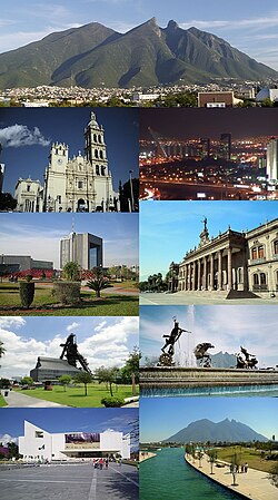
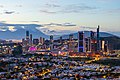
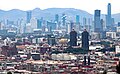
Monterrey metropolitan area
Metropolitan Area in Nuevo Leon, Mexico
Monterrey Metropolitan Area | ||
|---|---|---|
Metropolitan Area | ||
| Zona Metropolitana de la Ciudad de Monterrey (Spanish) | ||
 | ||
 Interactive Map of Monterrey Metropolitan Area
| ||
| Country |  Mexico Mexico | |
| State(s) |  Nuevo Leon Nuevo Leon | |
| Largest city | Monterrey | |
| Other cities | - Apodaca - Cadereyta Jiménez - El Carmen - Ciénega de Flores - Garcia - General Escobedo - General Zuazua - Guadalupe - Juárez - Pesquería - Salinas Victoria - San Nicolás de los Garza - San Pedro Garza García - Santa Catarina - Santiago | |
| Area | ||
| • Total | 2,957 sq mi (7,658 km2) | |
| Highest elevation | 4,900 ft (1,500 m) | |
| Lowest elevation | 1,680 ft (512 m) | |
| Population (2020 census)[1] | ||
| • Total | 5,341,177 | |
| • Density | 1,800/sq mi (700/km2) | |
| GDP (PPP, constant 2015 values) | ||
| • Year | 2023 | |
| • Total | $190.3 billion[2] | |
| • Per capita | $37,200 | |
| Time zone | UTC−6 (CST) | |
| Area code | 81 | |
The Monterrey metropolitan area refers to the surrounding urban agglomeration of Monterrey, Nuevo León. Officially called Area Metropolitana de la Ciudad de Monterrey or AMM, the metropolitan area is the 2nd-largest in Mexico.
Overview
The Monterrey metropolitan area is composed of the municipalities/cities of:
- Apodaca
- Cadereyta Jiménez
- El Carmen
- Escobedo
- García
- Guadalupe
- Juárez
- Monterrey
- Salinas Victoria
- San Nicolás de los Garza
- San Pedro Garza García
- Santa Catarina
- Santiago
There are three adjacent towns that do not maintain continuous urban development with the core urban area. These towns are considered strategic as the metropolitan area grows and integrates them:
See also
References
External links
 Media related to Monterrey metropolitan area at Wikimedia Commons
- INEGI - Statistics of the ZMM - 2001
- https://www.nuevoleon.gob.mx
- v
- t
- e

| |||||||||||||||||||||||||||||||||||||||||||||||||||||||||||||||||||||||||||||||||||||||||||||
|---|---|---|---|---|---|---|---|---|---|---|---|---|---|---|---|---|---|---|---|---|---|---|---|---|---|---|---|---|---|---|---|---|---|---|---|---|---|---|---|---|---|---|---|---|---|---|---|---|---|---|---|---|---|---|---|---|---|---|---|---|---|---|---|---|---|---|---|---|---|---|---|---|---|---|---|---|---|---|---|---|---|---|---|---|---|---|---|---|---|---|---|---|---|
| |||||||||||||||||||||||||||||||||||||||||||||||||||||||||||||||||||||||||||||||||||||||||||||


 | This article about a location in the Mexican state of Nuevo León is a stub. You can help Wikipedia by expanding it. |
- v
- t
- e


