Chetpet (Chennai)
Neighbourhood in Chennai, Tamil Nadu, India
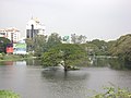
13°04′27″N 80°14′33″E / 13.07412°N 80.24238°E / 13.07412; 80.24238Chetpet is a neighbourhood in the Indian city of Chennai It is served by the Chetpet railway station in the Beach–Tambaram line of Chennai Suburban Railway. Chetpet has a pond between the Chetpet railway station and the Poonamallee High Road, one of the last surviving natural water bodies in the city. It is the locality in Chennai where the mathematician Ramanujan died.[1]
History
Along with Egmore and Nungambakkam, Chetpet is considered one of the original villages merged by the British to form Chennai.[2][3][4]
Development
Until recently, the waters of Chetpet lake supplied groundwater recharge for the surrounding neighbourhoods.[5]
Location – Chetpet
Chetpet is located at the center of Chennai, not far from Egmore railway station. CMBT is 8 km from Chetpet.Chetpet Eco Park is a famous landmark in this loacality.
Educational institutions
- Auxilium Girls Higher Secondary School
- Lady Andal Venkata Subba Rao Matriculation School
- Madras Christian College Higher Secondary School
- Madras Christian College Matriculation Higher Secondary School
- Maharishi Vidya Mandir Senior Secondary School
- Sherwood Hall Senior Secondary School
- The Madras Seva Sadan Higher Secondary School
- Union Christian Matriculation Higher Secondary School
Gallery
-
 Chetpet village in 1905
 -

-

-
-
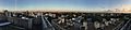 Chetpet View


Location in context
Areas of Chennai | |
|---|---|


References
 India portal

Wikimedia Commons has media related to Chetput.
- ^ "Squaring the circle". The Hindu. Vol. 132, no. 102. 23 April 2006. p. 3. Retrieved 18 September 2016.
- ^ History of Chennai
- ^ Nungambakkam
- ^ Dinamalar.com "சென்னையும் சிவப்பு நிற கட்டடங்களும்"
- ^ Lakshmi, K. (30 April 2009). "Hyacinth robbing Chetpet lake of life". The Hindu. Vol. 132, no. 102. p. 3. Archived from the original on 3 May 2009. Retrieved 1 May 2009.
- v
- t
- e
Neighbourhoods of Chennai (city)
- Adyar
- Adambakkam
- Adayalampattu
- Alapakkam
- Alandur
- Alwarpet
- Alwarthirunagar
- Ambattur
- Aminjikarai
- Anna Nagar
- Anna Nagar West
- Annanur
- Andarkuppam
- Arumbakkam
- Ashok Nagar
- Athipattu
- Avadi
- Ayanavaram
- Besant Nagar
- Chepauk
- Chembarambakkam
- Chengalpattu
- Chetput
- Choolai
- Choolaimedu
- Edayanchavadi
- Egmore
- Ennore
- Ernavoor
- Foreshore Estate
- Georgetown
- Greenways Road
- Guduvancheri
- Gummidipoondi
- Guindy
- Guindy TVK Estate
- ICF Colony
- Injambakkam
- Irumbuliyur
- Irungattukottai
- The Island
- Jawahar Nagar
- K. K. Nagar
- Kandanchavadi
- Kannammapet
- Karapakkam
- Karanodai
- Kathivakkam
- Kattankulathur
- Kavaraipettai
- Kelambakkam
- Kilambakkam
- Kilpauk
- Kanathur
- Kodambakkam
- Kodungaiyur
- Kolathur
- Komakkambedu
- Korattur
- Kosappur
- Kottivakkam
- Kotturpuram
- Kovalam
- Kovilambakkam
- Koyambedu
- Kundrathur
- Madipakkam
- Madhavaram
- Madhavaram Milk Colony
- Maduravoyal
- Mamallapuram
- Manali
- Manali New Town
- Manapakkam
- Mandavelli
- Mangadu
- Manjambakkam
- Maraimalai Nagar
- Mathur
- Medavakkam
- Meenambakkam
- Minjur
- Mogappair
- Moolakadai
- Muttukadu
- Mylapore
- Nandanam
- Nandambakkam
- Nandiambakkam
- Nanganallur
- Navalur
- Neelankarai
- Nerkundram
- Nesapakkam
- Nolambur
- Nungambakkam
- Padi
- Palavakkam
- Palavanthangal
- Pallikaranai
- Panagal Park
- Park Town
- Parry's Corner
- Pattabiram
- Pattaravakkam
- Pazhaverkadu
- Perambur
- Periapalayam
- Perumbakkam
- Perungudi
- Pondy Bazaar
- Ponneri
- Poonamallee
- Porur
- Potheri
- Pudhur
- Purasawalkam
- Puzhal
- Puzhuthivakkam
- Red Hills
- Royapettah
- Royapuram
- Sadayankuppam
- Saidapet
- Santhome
- Semmencherry
- Sholavaram
- Sholinganallur
- Shenoy Nagar
- Singaperumalkoil
- Siruseri
- Sithalapakkam
- Sriperumbudur
- Sunguvarchatram
- Surapet
- Sowcarpet
- St. Thomas Mount
- T. Nagar
- Tharamani
- Teynampet
- Thirumangalam
- Thirumazhisai
- Thirumullaivoyal
- Thiruninravur
- Thiruvanmiyur
- Thiruvidandhai
- Thiruporur
- Thuraipakkam
- Tirusulam
- Tiruverkadu
- Tiruvottiyur
- Tolgate
- Tondiarpet
- Triplicane
- Trustpuram
- Urapakkam
- Vadapalani
- Vadaperumbakkam
- Valasaravakkam
- Vallalar Nagar
- Vanagaram
- Vandalur
- Velachery
- Veppampattu
- Vichoor
- Villivakkam
- Vinayagapuram
- Virugambakkam
- Vyasarpadi
- Washermanpet
- West Mambalam


This city of Chennai location article is a stub. You can help Wikipedia by expanding it. |
- v
- t
- e


