Metropolitan Transport Corporation, Chennai, buses ply across Agaram, to and fro the places mentioned above. And also the following are well connected with road transport facilities.
Puratchi Thalaivar Dr. M. G. Ramachandran Central railway station.
Egmore Chennai railway station.
Rail transport
Connectivity to the following railway stations is appreciated.
Perambur Carriage Works railway station.
Perambur Carriage Works railway station.
Perambur railway station.
Puratchi Thalaivar Dr M. G. Ramachandran Central railway station.
^https://books.google.co.in>books>Fort Saint George Gazette - Page 26 .. west of Sundararaja Perumal koil streets in sub zones 5 and 7... - Madras (India:State) - 1964 - Snippet view
^https://books.google.co.in>books>Sundararaja Perumal koil streets>Corporation of Madras: Divisions and Streets - Page A-102 - 1988 - Snippet view
^https://books.google.com>books>Sundararaja Perumal koil streets>Corporation of Madras: Divisions and Streets - Page 46>Sl.No.29
^https://books.google.com>books>Kanakar street>Corporation of Madras: Division and streets - Page 46>Sl.No. 28> - 1988 - Snippet view.
^https://news.google.com>The Free Press Journal>India>Here is the list of...that Chennai...zone list>Sl.No. 150>Moorthy Street, Agaram - published on May 22, 2020
^https://books.google.com>books>Corporation of Madras: Divisions and Streets - Page 46>Sl.No.27
^"Agaram Locality Map, Chennai". Mapsofindia.com. 27 May 2013. Retrieved 24 July 2016.

 Shri Sundararaja Perumal Temple Tower backed by blue sky, Agaram, Perambur, Chennai, Tamil Nadu, India.
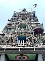 Shri Sundararaja Perumal Temple Tower, Agaram, Perambur, Chennai, Tamil Nadu. India.


 Category
 India portal
 WikiProject
 Category .
  India portal .


