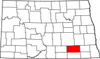
LaMoure County
County in de Verenigde Staten  | |||
|---|---|---|---|
 | |||
| Situering | |||
| Staat | North Dakota | ||
| Tijdzone | Central Standard Time (UTC−6) | ||
| Coördinaten | 46°28'12"NB, 98°31'48"WL | ||
| Algemeen | |||
| Oppervlakte | 2.980 km² | ||
| - land | 2.971 km² | ||
| - water | 9 km² | ||
| Inwoners (2000) | 4.701 (2 inw./km²) | ||
| Overig | |||
| Zetel | LaMoure | ||
| FIPS-code | 38045 | ||
| Opgericht | 1873 | ||
| Foto's | |||
 Bevolkingspiramide LaMoure County | |||
| Statistieken volkstelling LaMoure County | |||
| |||

LaMoure County is een county in de Amerikaanse staat North Dakota.
De county heeft een landoppervlakte van 2.971 km² en telt 4.701 inwoners (volkstelling 2000). De hoofdplaats is LaMoure.
Bevolkingsontwikkeling
| Jaar | Inwoners | % ± | |
|---|---|---|---|
| 1900 | 6.048 | — | |
| 1910 | 10.724 | 77,3% | |
| 1920 | 11.564 | 7,8% | |
| 1930 | 11.517 | −0,4% | |
| 1940 | 10.298 | −10,6% | |
| 1950 | 9.498 | −7,8% | |
| 1960 | 8.705 | −8,3% | |
| 1970 | 7.117 | −18,2% | |
| 1980 | 6.473 | −9,0% | |
| 1990 | 5.383 | −16,8% | |
| 2000 | 4.701 | −12,7% | |
| Bron: (en) Historical Decennial Census Population | |||

Adams County · Barnes County · Benson County · Billings County · Bottineau County · Bowman County · Burke County · Burleigh County · Cass County · Cavalier County · Dickey County · Divide County · Dunn County · Eddy County · Emmons County · Foster County · Golden Valley County · Grand Forks County · Grant County · Griggs County · Hettinger County · Kidder County · La Moure County · Logan County · McHenry County · McIntosh County · McKenzie County · McLean County · Mercer County · Morton County · Mountrail County · Nelson County · Oliver County · Pembina County · Pierce County · Ramsey County · Ransom County · Renville County · Richland County · Rolette County · Sargent County · Sheridan County · Sioux County · Slope County · Stark County · Steele County · Stutsman County · Towner County · Traill County · Walsh County · Ward County · Wells County · Williams County


