War Horse National Wildlife Refuge
Wildlife refuge in Montana, USA
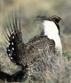
46°53′34″N 108°29′18″W / 46.89278°N 108.48833°W / 46.89278; -108.48833[1]War Horse National Wildlife Refuge, located in the center of the U.S. state of Montana, is divided into three separate sections, with each centered on a small body of water.[2][3] It is an integral part of the Charles M. Russell National Wildlife Refuge Complex, although the refuge is normally unstaffed and has few visitor improvements. One reservoir is stocked with rainbow trout, although the lake is sometimes empty. When the lakes and reservoirs are fully filled, the refuge provides excellent habitat for migratory bird species. The region is surrounded by sagebrush plains and Ponderosa pine groves that flourish in the region solely due to its acid-shale soils. Along with over 100 bird species, regular inhabitants include Sage Grouse, pronghorn and mule deer.[4]
References
- ^ "War Horse National Wildlife Refuge". Geographic Names Information System. United States Geological Survey, United States Department of the Interior. Retrieved March 9, 2014.
- ^ Teigen, MT (Map). Topoquest (USGS Quads). Retrieved March 9, 2014.
- ^ "Annual Report of Lands Under Control of the U.S. Fish and Wildlife Service" (pdf). U.S. Fish and Wildlife Service. September 30, 2010. p. 23. Retrieved March 9, 2014.
- ^ "War Horse National Wildlife Refuge". U.S. Fish and Wildlife Service. Retrieved March 9, 2014.
External links
- War Horse National Wildlife Refuge
- v
- t
- e
Protected areas of Montana
| National parks |
|
|---|---|
| National monuments | |
| National battlefield | |
| National historical parks and historic sites | |
| National historic and scenic trails | |
| National recreation area | |
| National Wildlife Refuges | |
| National Forests | |
| National Wilderness | |
| National wild and scenic rivers |
| State parks |
|
|---|---|
| State forests | |
| Wildlife Management Areas |
|
| Nonprofit | |
|---|---|
| Tribal |
| Authority control databases |
|
|---|
 | This Montana protected area article is a stub. You can help Wikipedia by expanding it. |
- v
- t
- e
 | This Petroleum County, Montana state location article is a stub. You can help Wikipedia by expanding it. |
- v
- t
- e


