Vollrathsruhe
Municipality in Mecklenburg-Vorpommern, Germany
Location of Vollrathsruhe within Mecklenburgische Seenplatte district

53°38′35″N 12°29′24″E / 53.64306°N 12.49000°E / 53.64306; 12.49000
(2022-12-31)[1]
17194
Vollrathsruhe is a municipality in the Mecklenburgische Seenplatte district, in Mecklenburg-Vorpommern, in north-eastern Germany.
History
During World War II, in February 1945, a German-perpetrated death march of Allied prisoners-of-war from the Stalag XX-B POW camp passed through the village.[2]
Sights
- Village Church, Kirch Grubenhagen.
- Vollrathsruhe Estate with two-storey, 13-wing country house, park and mausoleum
- Dat lange Hus in Hallalit is of architectural interest: at 104 metres long, it is the longest fieldstone house in the region. This cottage was built in the mid-19th century for 16 families.
- Ruins of the 13th-century Grubenhagen Castle in Vollrathsruhe
- Protected central avant-corps of a building in Kirch Grubenhagen, Teterower Str. 3
- Schloss Grubenhagen country house and park
- Hellgrund Nature Reserve, Klein Rehberg and
- Wüste und Glase Nature Reserve in Klein Luckow with a Bronze Age/Slavic burgwall.
Gallery
-
 Church in Kirch Grubenhagen
 -
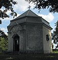 Chapel in the schloss park of Vollrathsruhe
 -
 Fieldstone building in Vollrathsruhe
 -
 Building in Kirch Grubenhagen, Teterower Str. 3
 -
 Viewing tower
 -
 2014 aerial photograph of the castle


References
- ^ "Bevölkerungsstand der Kreise, Ämter und Gemeinden 2022" (XLS) (in German). Statistisches Amt Mecklenburg-Vorpommern. 2023.
- ^ Kaszuba, Sylwia. "Marsz 1945". In Grudziecka, Beata (ed.). Stalag XX B: historia nieopowiedziana (in Polish). Malbork: Muzeum Miasta Malborka. p. 102. ISBN 978-83-950992-2-9.
- v
- t
- e
Towns and municipalities in Mecklenburgische Seenplatte
- Altenhagen
- Altenhof
- Altentreptow
- Alt Schwerin
- Ankershagen
- Bartow
- Basedow
- Beggerow
- Beseritz
- Blankenhof
- Blankensee
- Blumenholz
- Bollewick
- Borrentin
- Bredenfelde
- Breesen
- Breest
- Briggow
- Brunn
- Buchholz
- Burg Stargard
- Burow
- Bütow
- Carpin
- Cölpin
- Dargun
- Datzetal
- Demmin
- Eldetal
- Faulenrost
- Feldberger Seenlandschaft
- Fincken
- Friedland
- Fünfseen
- Galenbeck
- Gielow
- Gnevkow
- Godendorf
- Göhren-Lebbin
- Golchen
- Gotthun
- Grabowhöfe
- Grammentin
- Grapzow
- Grischow
- Groß Kelle
- Groß Miltzow
- Groß Nemerow
- Groß Plasten
- Groß Teetzleben
- Grünow
- Gültz
- Gülzow
- Hohenbollentin
- Hohenmocker
- Hohen Wangelin
- Hohenzieritz
- Holldorf
- Ivenack
- Jabel
- Jürgenstorf
- Kargow
- Kentzlin
- Kieve
- Kittendorf
- Klein Vielen
- Kletzin
- Klink
- Klocksin
- Knorrendorf
- Kratzeburg
- Kriesow
- Kublank
- Kuckssee
- Kummerow
- Lärz
- Leizen
- Lindenberg
- Lindetal
- Malchin
- Malchow
- Meesiger
- Melz
- Mirow
- Möllenbeck
- Möllenhagen
- Mölln
- Moltzow
- Neddemin
- Neetzka
- Neubrandenburg
- Neuenkirchen
- Neukalen
- Neustrelitz
- Neverin
- Nossendorf
- Nossentiner Hütte
- Penzlin
- Peenehagen
- Pragsdorf
- Priborn
- Priepert
- Pripsleben
- Rechlin
- Ritzerow
- Röbel
- Röckwitz
- Rosenow
- Sarow
- Schloen-Dratow
- Schönbeck
- Schönfeld
- Schönhausen
- Schwarz
- Siedenbollentin
- Siedenbrünzow
- Sietow
- Silz
- Sommersdorf
- Sponholz
- Staven
- Stavenhagen
- Stuer
- Südmüritz
- Torgelow am See
- Trollenhagen
- Tützpatz
- Userin
- Utzedel
- Verchen
- Voigtsdorf
- Vollrathsruhe
- Walow
- Waren (Müritz)
- Warrenzin
- Werder
- Wesenberg
- Wildberg
- Woggersin
- Wokuhl-Dabelow
- Wolde
- Woldegk
- Wulkenzin
- Wustrow
- Zettemin
- Zirzow
- Zislow

Authority control databases | |
|---|---|
| International |
|
| National |
|
 | This Mecklenburgische Seenplatte (district) location article is a stub. You can help Wikipedia by expanding it. |
- v
- t
- e


