Twelveheads
Human settlement in England


Twelveheads
Location within Cornwall
- Chacewater
- Cornwall
- Cornwall
- South West
- Truro and Falmouth
Twelveheads (Cornish: Dewdhek Stamp) is a hamlet east of St Day in west Cornwall, England, United Kingdom.[1] It lies in the parish of Chacewater, between Truro and Redruth.
History and geography
The name comes from the hamlet's mining history. Sets of stamps (machines used for crushing ore) were once used on the dressing floors in the village. The stamps had a total of twelve 'heads'.
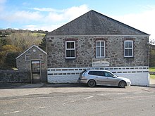
Twelveheads has a Methodist chapel; Billy Bray, the Methodist preacher, was born here. The former village pub and post office are both now private housing.
Twelveheads is close to the Coast to Coast cycle route and the former mine known as Wheal Busy. There is also the 'Twelveheads Gate' into the Poldice Valley - the path of the mineral tramway, popular with cyclists, horseriders and walkers. About 500 yards to the south-east, down the Carnon Valley, is the portal of the Great County Adit that once drained all the mines in the locality.
See also
 Cornwall portal

References
Wikimedia Commons has media related to Twelveheads.
- ^ Ordnance Survey One-inch Map of Great Britain; Truro and Falmouth, sheet 190. 1961
- v
- t
- e

Cornwall Portal
(cities in italics)
- Bodmin
- Bude
- Callington
- Camborne
- Camelford
- Falmouth
- Fowey
- Hayle
- Helston
- Hugh Town
- Launceston
- Liskeard
- Looe
- Lostwithiel
- Marazion
- Newlyn
- Newquay
- Padstow
- Penryn
- Penzance
- Porthleven
- Redruth
- St Austell
- St Blazey
- St Columb Major
- St Ives
- St Just in Penwith
- Saltash
- Stratton
- Torpoint
- Truro
- Wadebridge
See also: List of civil parishes in Cornwall
 | This article about a location in the former district of Carrick, Cornwall is a stub. You can help Wikipedia by expanding it. |
- v
- t
- e


