Tonosí District
District in Los Santos Province, Panama

Seal

 Panama
 (2020)[1]
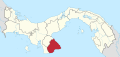
Tonosí District is a district (distrito) of Los Santos Province in Panama. The population according to the 2000 census was 9,736.[2] The district covers a total area of 1,294 km². The capital lies at the city of Tonosí.[2]
Administrative divisions
Tonosí District is divided administratively into the following corregimientos:
- Tonosí (capital)
- Altos de Guera
- Cañas
- El Bebedero
- El Cacao
- El Cortezo
- Flores
- Guánico
- La Tronosa
- Cambutal
- Isla de Cañas
References
- ^ "Tonosí (District, Panama) - Population Statistics, Charts, Map and Location". www.citypopulation.de. Retrieved 2023-10-05.
- ^ a b "Districts of Panama". Statoids. Retrieved April 12, 2009.
- v
- t
- e

Capital: Las Tablas
| |
|---|---|
| Bocas del Toro Province | |
| Chiriquí Province | |
| Coclé Province | |
| Colón Province | |
| Darién Province | |
| Herrera Province | |
| Los Santos Province | |
| Panamá Province | |
| Veraguas Province | |
| West Panamá Province | |
7°24′0″N 80°26′24″W / 7.40000°N 80.44000°W / 7.40000; -80.44000
This article about the geography of Los Santos Province is a stub. You can help Wikipedia by expanding it. |
- v
- t
- e


