Solano, Caquetá
Municipality and town in Caquetá Department, Colombia

Flag

Seal
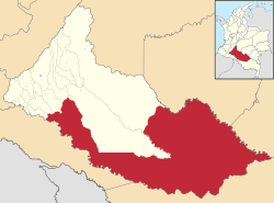
Location of the municipality and town of Solano in the Caquetá Department of Colombia.
 Colombia
 (Census 2018[1])
Solano is a town and municipality in Caquetá Department, Colombia.
Climate
| Climate data for Solano (Araracuara), elevation 150 m (490 ft), (1981–2010) | |||||||||||||
|---|---|---|---|---|---|---|---|---|---|---|---|---|---|
| Month | Jan | Feb | Mar | Apr | May | Jun | Jul | Aug | Sep | Oct | Nov | Dec | Year |
| Mean daily maximum °C (°F) | 31.9 (89.4) | 31.8 (89.2) | 31.6 (88.9) | 30.9 (87.6) | 30.2 (86.4) | 29.6 (85.3) | 29.7 (85.5) | 30.7 (87.3) | 31.4 (88.5) | 31.5 (88.7) | 31.5 (88.7) | 31.8 (89.2) | 31.1 (88.0) |
| Daily mean °C (°F) | 26.1 (79.0) | 26.4 (79.5) | 26.4 (79.5) | 25.9 (78.6) | 25.5 (77.9) | 25.2 (77.4) | 24.9 (76.8) | 25.4 (77.7) | 25.9 (78.6) | 26.1 (79.0) | 26.0 (78.8) | 26.3 (79.3) | 25.8 (78.4) |
| Mean daily minimum °C (°F) | 22.0 (71.6) | 22.1 (71.8) | 22.3 (72.1) | 22.4 (72.3) | 22.3 (72.1) | 21.8 (71.2) | 21.3 (70.3) | 21.4 (70.5) | 21.8 (71.2) | 22.1 (71.8) | 22.4 (72.3) | 22.2 (72.0) | 22.0 (71.6) |
| Average precipitation mm (inches) | 152.0 (5.98) | 199.1 (7.84) | 262.1 (10.32) | 395.6 (15.57) | 413.6 (16.28) | 358.6 (14.12) | 332.5 (13.09) | 263.3 (10.37) | 255.5 (10.06) | 261.3 (10.29) | 243.3 (9.58) | 200.0 (7.87) | 3,337 (131.38) |
| Average precipitation days | 14 | 15 | 18 | 22 | 24 | 24 | 23 | 21 | 19 | 17 | 18 | 15 | 220 |
| Average relative humidity (%) | 85 | 86 | 87 | 88 | 88 | 89 | 89 | 86 | 86 | 86 | 87 | 86 | 87 |
| Mean monthly sunshine hours | 155.0 | 141.2 | 130.2 | 126.0 | 124.0 | 123.0 | 142.6 | 164.3 | 159.0 | 164.3 | 159.0 | 164.3 | 1,752.9 |
| Mean daily sunshine hours | 5.0 | 5.0 | 4.2 | 4.2 | 4.0 | 4.1 | 4.6 | 5.3 | 5.3 | 5.3 | 5.3 | 5.3 | 4.8 |
| Source: Instituto de Hidrologia Meteorologia y Estudios Ambientales[2] | |||||||||||||
| Climate data for Solano (Tres Esquinas), elevation 219 m (719 ft), (1981–2010) | |||||||||||||
|---|---|---|---|---|---|---|---|---|---|---|---|---|---|
| Month | Jan | Feb | Mar | Apr | May | Jun | Jul | Aug | Sep | Oct | Nov | Dec | Year |
| Mean daily maximum °C (°F) | 32.6 (90.7) | 31.8 (89.2) | 30.7 (87.3) | 30.2 (86.4) | 29.8 (85.6) | 29.3 (84.7) | 29.3 (84.7) | 30.3 (86.5) | 31.1 (88.0) | 31.4 (88.5) | 31.5 (88.7) | 31.8 (89.2) | 30.8 (87.4) |
| Daily mean °C (°F) | 27.1 (80.8) | 26.3 (79.3) | 25.8 (78.4) | 25.5 (77.9) | 25.4 (77.7) | 24.7 (76.5) | 24.6 (76.3) | 25.0 (77.0) | 25.6 (78.1) | 25.8 (78.4) | 26.2 (79.2) | 26.6 (79.9) | 25.7 (78.3) |
| Mean daily minimum °C (°F) | 20.6 (69.1) | 20.5 (68.9) | 20.9 (69.6) | 20.8 (69.4) | 21.1 (70.0) | 20.5 (68.9) | 20.4 (68.7) | 20.3 (68.5) | 20.5 (68.9) | 20.6 (69.1) | 20.8 (69.4) | 20.4 (68.7) | 20.6 (69.1) |
| Average precipitation mm (inches) | 97.8 (3.85) | 143.3 (5.64) | 201.7 (7.94) | 315.0 (12.40) | 317.9 (12.52) | 335.2 (13.20) | 241.7 (9.52) | 221.4 (8.72) | 203.8 (8.02) | 186.1 (7.33) | 150.3 (5.92) | 143.9 (5.67) | 2,485.8 (97.87) |
| Average relative humidity (%) | 80 | 82 | 86 | 87 | 88 | 89 | 88 | 86 | 85 | 86 | 85 | 82 | 86 |
| Mean monthly sunshine hours | 179.8 | 118.6 | 108.5 | 99.0 | 105.4 | 102.0 | 120.9 | 133.3 | 144.0 | 164.3 | 159.0 | 186.0 | 1,620.8 |
| Mean daily sunshine hours | 5.8 | 4.2 | 3.5 | 3.3 | 3.4 | 3.4 | 3.9 | 4.3 | 4.8 | 5.3 | 5.3 | 6.0 | 4.4 |
| Source: Instituto de Hidrologia Meteorologia y Estudios Ambientales[2] | |||||||||||||
References
- ^ "Censo Nacional de Población y Vivienda 2018" (in Spanish). Retrieved 20 April 2020.
- ^ a b "Promedios Climatológicos 1981–2010" (in Spanish). Instituto de Hidrologia Meteorologia y Estudios Ambientales. Archived from the original on 15 August 2016. Retrieved 17 June 2024.

0°41′54″N 75°15′14″W / 0.69833°N 75.25389°W / 0.69833; -75.25389
 | This Caquetá Department location article is a stub. You can help Wikipedia by expanding it. |
- v
- t
- e


