Satrokala
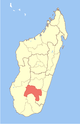
Place in Ihorombe, Madagascar
22°3′S 45°37′E / 22.050°S 45.617°E / -22.050; 45.617 Madagascar
 (2001)[2]
Satrokala is a town and commune in Madagascar. It belongs to the district of Ihosy, which is a part of Ihorombe Region. The population of the commune was estimated to be approximately 10,000 in 2001 commune census.[2]
Only primary schooling is available. The majority 70% of the population of the commune are farmers, while an additional 30% receives their livelihood from raising livestock. The most important crops are cassava and peanuts, while other important agricultural products are beans, rice and taro.[2]
References and notes
- ^ Estimated based on DEM data from Shuttle Radar Topography Mission
- ^ a b c "ILO census data". Cornell University. 2002. Retrieved 2008-04-24.
22°3′S 45°37′E / 22.050°S 45.617°E / -22.050; 45.617
 | This Ihorombe location article is a stub. You can help Wikipedia by expanding it. |
- v
- t
- e


