46°48′24″N119°33′28″W / 46.80667°N 119.55778°W / 46.80667; -119.55778The Saddle Mountains as seen from the ridgeline looking toward the east in the Wahluke Wildlife Refuge section; photo taken in the spring of 2007
The Saddle Mountains consists of an upfolded anticline ridge of basalt in Grant County of central Washington state. The ridge, reaching to 2,700 feet, terminates in the east south of Othello, Washington near the foot of the Drumheller Channels. It continues to the west where it is broken at Sentinel Gap (a water gap through which the Columbia River passes) before ending in the foothills of the Cascade Mountains.
Saddle Mountains geology
The top exposed layer of Columbia River Basalt Group basalt in the Saddle Mountains is the Saddle Mountain Basalt, which ranges from 120 – 240 meters (400 – 800 feet) in thickness and is interspersed by sedimentary layers of the Ellensburg Formation. The Saddle Mountain Basalt is composed of the Umatilla Member flows, the Wilbur Creek Member flows, the Asotin Member flows (13 million years ago), the Weissenfels Ridge Member flows, the Esquatzel Member flows, the Elephant Mountain Member flows (10.5 million years ago), the Bujford Member flows, the Ice Harbor Member flows (8.5 million years ago) and the Lower Monumental Member flows (6 million years ago).[1]
The Cordilleran Glacier diverted the ancient route of the Columbia River 15,000 years ago, backing up water to create Lake Spokane. As the Okanogan lobe grew the Columbia was rerouted into the Grand Coulee. Flowing across the current Grand Coulee-Dry Falls region, the ice-age Columbia then entered the Quincy Basin near Quincy, Washington and joined Crab Creek at Moses Lake, following Crab Creek's course southward past the Frenchman Hills and turning west to run along the north face of the Saddle Mountains, there to rejoin the previous and modern course of the Columbia River just above the main water gap in the Saddle Mountains, Sentinel Gap. It eroded the north face of the Saddle Mountains, creating the conditions for the Corfu Slide.[2][3][4]
Geography
Sentinel Gap in the Saddle Mountains as seen from the north
Location
Coordinates
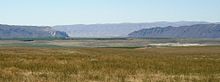
Eastern portion of Saddle Mountains where Lower Crab Creek meets the Corfu Slide
Sentinel Gap in the Saddle Mountains as seen from the west bank of the Columbia River above the Wanapum DamThe Saddle Mountains as seen from the John Wayne Pioneer Trail; photo looking east southeasterly at Boylston tunnel
^Carson, Robert J.; Pogue, Kevin R. (1996). Flood Basalts and Glacier Floods:Roadside Geology of Parts of Walla Walla, Franklin, and Columbia Counties, Washington. Washington State Department of Natural Resources (Washington Division of Geology and Earth Resources Information Circular 90). ISBN none.
^Bjornstad, Bruce (2006). On the Trail of the Ice Age Floods: A Geological Guide to the Mid-Columbif Basin. Keokee Books; San Point, Idaho. ISBN 978-1-879628-27-4.
^J Harlen Bretz, (1923), The Channeled Scabland of the Columbia Plateau. Journal of Geology, v.31, p.617-649
^Mueller, Ted and Marge (1997). Fire, Faults & Floods. University of Idaho Press, Moscow, Idaho. ISBN 0-89301-206-8.
External links
Washington State Park link
Commercial link to Saddle Mountain Management Area
U.S. Geological Survey Geographic Names Information System: Saddle Mountains