National Register of Historic Places listings in Tucker County, West Virginia

This is a list of the National Register of Historic Places listings in Tucker County, West Virginia.
This is intended to be a complete list of the properties and districts on the National Register of Historic Places in Tucker County, West Virginia, United States. The locations of National Register properties and districts for which the latitude and longitude coordinates are included below, may be seen in an online map.[1]
There are 11 properties and districts listed on the National Register in the county.
This National Park Service list is complete through NPS recent listings posted May 31, 2024.[2]
Map all coordinates using OpenStreetMap
Download coordinates as:
- KML
- GPX (all coordinates)
- GPX (primary coordinates)
- GPX (secondary coordinates)
Barbour - Berkeley - Boone - Braxton - Brooke - Cabell - Calhoun - Clay - Doddridge - Fayette - Gilmer - Grant - Greenbrier - Hampshire - Hancock - Hardy - Harrison - Jackson - Jefferson - Kanawha - Lewis - Lincoln - Logan - Marion - Marshall - Mason - McDowell - Mercer - Mineral - Mingo - Monongalia - Monroe - Morgan - Nicholas - Ohio - Pendleton - Pleasants - Pocahontas - Preston - Putnam - Raleigh - Randolph - Ritchie - Roane - Summers - Taylor - Tucker - Tyler - Upshur - Wayne - Webster - Wetzel - Wirt - Wood - Wyoming |
Current listings
| [3] | Name on the Register | Image | Date listed[4] | Location | City or town | Description |
|---|---|---|---|---|---|---|
| 1 | Buxton and Landstreet Company Store | Upload image | April 15, 2022 (#100007612) | 571 Douglas Rd. 39°08′33″N 79°30′25″W / 39.1424°N 79.5069°W / 39.1424; -79.5069 (Buxton and Landstreet Company Store) | Thomas | |
| 2 | Cottrill Opera House |  | August 29, 1979 (#79002602) | East Ave. 39°09′01″N 79°29′53″W / 39.1503°N 79.4981°W / 39.1503; -79.4981 (Cottrill Opera House) | Thomas | |
| 3 | Davis Coal and Coke Company Administrative Building |  | October 6, 2011 (#11000733) | 570 Douglas Rd. 39°08′33″N 79°30′12″W / 39.1425°N 79.5033°W / 39.1425; -79.5033 (Davis Coal and Coke Company Administrative Building) | Thomas | |
| 4 | Fairfax Stone Site |  | January 26, 1970 (#70000653) | North of William at corner of Grant, Preston, and Tucker counties 39°11′42″N 79°29′16″W / 39.195°N 79.4878°W / 39.195; -79.4878 (Fairfax Stone Site) | Thomas | |
| 5 | Herman August Meyer House | 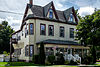 | July 15, 2010 (#09001195) | 287 Thomas Ave. 39°07′49″N 79°27′48″W / 39.1303°N 79.4633°W / 39.1303; -79.4633 (Herman August Meyer House) | Davis | |
| 6 | National Bank of Davis |  | July 6, 2020 (#100005315) | 417 William Ave. 39°07′44″N 79°27′54″W / 39.1288°N 79.4651°W / 39.1288; -79.4651 (National Bank of Davis) | Davis | |
| 7 | St. George Academy |  | November 29, 2001 (#01001333) | County Road 1 39°09′49″N 79°41′57″W / 39.1636°N 79.6992°W / 39.1636; -79.6992 (St. George Academy) | St. George | |
| 8 | Thomas Commercial Historic District |  | August 14, 1998 (#98001072) | Roughly Spruce St. and East Ave. between First St. and Third St.; East Ave. west to the North Fork of the Blackwater River 39°09′46″N 79°29′34″W / 39.1628°N 79.4928°W / 39.1628; -79.4928 (Thomas Commercial Historic District) | Thomas | |
| 9 | Tucker County Bank Building |  | August 26, 2010 (#10000579) | 1000 Walnut St. 39°05′49″N 79°40′47″W / 39.0970°N 79.6798°W / 39.0970; -79.6798 (Tucker County Bank Building) | Parsons | |
| 10 | Tucker County Courthouse and Jail |  | August 23, 1984 (#84003680) | 1st and Walnut Sts. 39°05′49″N 79°40′51″W / 39.0969°N 79.6808°W / 39.0969; -79.6808 (Tucker County Courthouse and Jail) | Parsons | |
| 11 | Western Maryland Depot |  | May 2, 1996 (#96000444) | 166½ Main St. 39°05′44″N 79°40′50″W / 39.0956°N 79.6806°W / 39.0956; -79.6806 (Western Maryland Depot) | Parsons |
See also
Wikimedia Commons has media related to National Register of Historic Places in Tucker County, West Virginia.
- List of National Historic Landmarks in West Virginia
- National Register of Historic Places listings in West Virginia
References
- ^ The latitude and longitude information provided in this table was derived originally from the National Register Information System, which has been found to be fairly accurate for about 99% of listings. Some locations in this table may have been corrected to current GPS standards.
- ^ National Park Service, United States Department of the Interior, "National Register of Historic Places: Weekly List Actions", retrieved May 31, 2024.
- ^ Numbers represent an alphabetical ordering by significant words. Various colorings, defined here, differentiate National Historic Landmarks and historic districts from other NRHP buildings, structures, sites or objects.
- ^ The eight-digit number below each date is the number assigned to each location in the National Register Information System database, which can be viewed by clicking the number.
- v
- t
- e

county
- Barbour
- Berkeley
- Boone
- Braxton
- Brooke
- Cabell
- Calhoun
- Clay
- Doddridge
- Fayette
- Gilmer
- Grant
- Greenbrier
- Hampshire
- Hancock
- Hardy
- Harrison
- Jackson
- Jefferson
- Kanawha
- Lewis
- Lincoln
- Logan
- Marion
- Marshall
- Mason
- McDowell
- Mercer
- Mineral
- Mingo
- Monongalia
- Monroe
- Morgan
- Nicholas
- Ohio
- Pendleton
- Pleasants
- Pocahontas
- Preston
- Putnam
- Raleigh
- Randolph
- Ritchie
- Roane
- Summers
- Taylor
- Tucker
- Tyler
- Upshur
- Wayne
- Webster
- Wetzel
- Wirt
- Wood
- Wyoming
 Category:National Register of Historic Places in West Virginia
 Portal:National Register of Historic Places


Municipalities and communities of Tucker County, West Virginia, United States | ||
|---|---|---|
County seat: Parsons | ||
| Cities |  | |
| Towns | ||
| CDP | ||
| Other communities | ||
| Ghost towns | ||
| ||


