Lithuania District
| Lithuania District Verwaltungsbezirk Litauen | |||||||||||
|---|---|---|---|---|---|---|---|---|---|---|---|
| Military occupation authority of the German Empire | |||||||||||
| 1915–1918 | |||||||||||
 Flag | |||||||||||
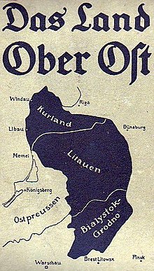 Map of Ober Ost | |||||||||||
| Capital | Vilnius | ||||||||||
| Area | |||||||||||
| 54°41′N 25°17′E / 54.683°N 25.283°E / 54.683; 25.283 | |||||||||||
| History | |||||||||||
• Established | 1915 | ||||||||||
• Disestablished | 1918 | ||||||||||
| |||||||||||


Lithuania District (German: Verwaltungsbezirk Litauen) was an administrative division of German-controlled territory of Ober-Ost during World War I. It was bordered by the Bialystok-Grodno District to the south and the Courland District to the north.[1][2]
History
The area was formed roughly from parts of the former Vilna Governorate and Suvalki Governorate of the Russian Empire.
References
- v
- t
- e
  | This Lithuanian history-related article is a stub. You can help Wikipedia by expanding it. |
- v
- t
- e
 | This Polish history–related article is a stub. You can help Wikipedia by expanding it. |
- v
- t
- e
 | This Russian history–related article is a stub. You can help Wikipedia by expanding it. |
- v
- t
- e


