Kostolec
Municipality in Slovakia
49°08′N 18°32′E / 49.133°N 18.533°E / 49.133; 18.533 (2021)
017 05[3]
Kostolec (Hungarian: Kosfalu) is a village and municipality in Považská Bystrica District in the Trenčín Region of north-western Slovakia.
History
In historical records the village was first mentioned in 1430.
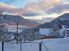
Geography
The municipality lies at an altitude of 495 metres and covers an area of 4.001 km2. It has a population of about 256 people.
Genealogical resources
The records for genealogical research are available at the state archive "Statny Archiv in Bytca, Slovakia"
- Roman Catholic church records (births/marriages/deaths): 1764-1895 (parish B)
- Lutheran church records (births/marriages/deaths): 1801-1907 (parish B)
See also
References
- ^ "Počet obyvateľov podľa pohlavia - obce (ročne)". www.statistics.sk (in Slovak). Statistical Office of the Slovak Republic. 2022-03-31. Retrieved 2022-03-31.
- ^ a b "Hustota obyvateľstva - obce [om7014rr_ukaz: Rozloha (Štvorcový meter)]". www.statistics.sk (in Slovak). Statistical Office of the Slovak Republic. 2022-03-31. Retrieved 2022-03-31.
- ^ a b c d "Základná charakteristika". www.statistics.sk (in Slovak). Statistical Office of the Slovak Republic. 2015-04-17. Retrieved 2022-03-31.
- ^ a b "Hustota obyvateľstva - obce". www.statistics.sk (in Slovak). Statistical Office of the Slovak Republic. 2022-03-31. Retrieved 2022-03-31.
External links
![]() Media related to Kostolec at Wikimedia Commons
Media related to Kostolec at Wikimedia Commons
- Official website

- https://web.archive.org/web/20090412234949/http://www.statistics.sk/mosmis/eng/run.html
- Surnames of living people in Kostolec

 | This Trenčín District location article is a stub. You can help Wikipedia by expanding it. |
- v
- t
- e


