Hohe Acht


Hohe Acht
Rheinland-Pfalz, Germany
The Hohe Acht (German: [ˌhoːə ˈʔaxt]) is the highest mountain (746.9 m above sea level (NHN)[1][2]) in the Eifel mountains of Germany. It is located on the boundary between the districts of Ahrweiler and Mayen-Koblenz in Rhineland-Palatinate.
Geography and geology

The Hohe Acht is located in the High Eifel east of Adenau. The mountain is a Tertiary volcano, whose cone is composed of Lower Devonian rock and whose summit is made of basalt.
Emperor William Tower
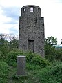
In 1908/09 the Emperor William Tower (Kaiser-Wilhelm-Turm) was erected on the Hohe Acht. The occasion for the construction of this stone observation tower, based on plans by the architect, Freiherr von Tettau of Berlin, was the silver wedding of Emperor William II and Empress Augusta Victoria as well as the commemoration of Emperor William I
The tower is 16.30 metres (53.5 ft) high and its walls are one metre thick at ground level. The work was carried out by master masons, Karl and Johannes Leidinger, from Adenau using local stone. The cost of construction was 18,000 marks. The tower has been a protected monument since 1987.
The Emperor William Tower offers a superb view across the whole Eifel (including the mountains of Scharteberg, Döhmberg, Michelsberg, Hochthürmerberg, Schöneberg, the nearby Nürburg Castle and Hochkelberg), as well as the Siebengebirge and its Großer Ölberg and, in conditions of good visibility, as far as the Westerwald, the Taunus, the Hunsrück and the Lower Rhine.
Walking and winter sports
There is a network of footpaths around the Hohe Acht; at many places there are good views over the Eifel landscape.
In winter the Hohe Acht has good winter sport facilities including prepared cross country skiing trails, toboggan runs and ski lifts.
Motor racing
Very close to the Hohe Acht on a 678 metres (2,224 ft) high volcanic cone is Nürburg Castle. A section of the North loop (Nordschleife) on the Formula 1 racetrack at the Nürburgring is known as the Hohe Acht.
-
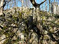 Basaltic blocks on the summit of the Hohe Acht
 -
 Summit rock on the Hohe Acht with the Kaiser Wilhelm Tower behind
 -
 Kaiser Wilhelm Tower
 -
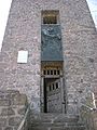
 On the Kaiser Wilhelm Tower


References
- ^ a b Map services of the Federal Agency for Nature Conservation
- ^ a b Map service of the Landscape Information System of the Rhineland-Palatinate Nature Conservation Office (Naturschutzverwaltung Rheinland-Pfalz)
- ^ Prominence from Eberhard Jurgalski, Summits in Germany with at least 379 meters of re-ascent – auf sol.co.uk at the Wayback Machine (archived 2006-01-18).
Sources
- d'Hein: Nationaler Geopark Vulkanland Eifel. Ein Natur- und Kulturführer. Gaasterland Verlag, Düsseldorf 2006, ISBN 3-935873-15-8
External links
- WDR Winter Sport Tip – Hohe Acht (in German)
- Rhineland-Palatinate Leisure Portal – Hohe Acht (in German)
- v
- t
- e
Central Uplands of Germany
- Anterior Bavarian Forest Einödriegel
- Black Forest Feldberg
- Bohemian Forest Großer Arber (Bavarian Forest Großer Arber)
- Deister Bröhn
- Ebbe Mountains Nordhelle
- Egge Mountains (Prussian) Velmerstot
- Eifel Hohe Acht (Volcanic Eifel Ernstberg)
- Elbe Sandstone Mountains Großer Zschirnstein
- Elm Eilumer Horn
- Elster Mountains Kapellenberg
- Fichtel Mountains Schneeberg (Steinwald Platte, Kohlwald Sieben-Linden-Berg)
- Franconian Forest Döbraberg
- Franconian Jura Dürrenberg
- Gladenbach Uplands Angelburg
- Goshawk Forest Hohes Gras
- Harz Brocken (Blocksberg)
- Hildesheim Forest Griesberg
- Hils Bloße Zelle
- Hoher Meißner Kasseler Kuppe
- Hunsrück Erbeskopf (Soonwald Ellerspring)
- Ith Lauensteiner Kopf
- Kaiserstuhl Totenkopf
- Kaufungen Forest Hirschberg
- Kellerwald Wüstegarten
- Knüll Eisenberg
- Kyffhäuser Kulpenberg
- Lenne Mountains Homert
- Lippe Uplands Köterberg
- North Palatine Uplands Donnersberg
- Odenwald Katzenbuckel
- Ore Mountains Fichtelberg
- Palatine Forest Kalmit
- Rhön Wasserkuppe
- Rothaar Mountains Langenberg
- Saalhausen Hills Himberg
- Siebengebirge Großer Ölberg
- Solling Große Blöße
- Spessart Geiersberg (Breitsol)
- Sudetes Lausche (Luž) (Lusatian Mountains Lausche (Luž) (Zittau Mountains Lausche (Luž)))
- Süntel Hohe Egge
- Swabian Jura Lemberg (Randen Hoher Randen)
- Taunus Großer Feldberg
- Teutoburg Forest (Osning) Barnacken
- Thuringian Forest Großer Beerberg
- Thuringian Slate Mountains Großer Farmdenkopf
- Upper Palatine Forest Kreuzfelsen
- Vogelsberg Taufstein
- Weser Hills Paschenburg Mountain
- Westerwald Fuchskaute
- Wiehen Hills Heidbrink

Authority control databases | |
|---|---|
| International |
|
| National |
|


