Greyrock Mountain National Recreation Trail
Hiking trail in Colorado, United States
| Greyrock Mountain Trail | |
|---|---|
 Greyrock Mountain Trail | |
| Length | 3.1 miles (5.0 km)[1] |
| Location | Roosevelt National Forest, Colorado, United States |
| Designation | National Recreation Trail |
| Use | Hiking |
| Elevation change | 2,039 feet (621 m)[1] |
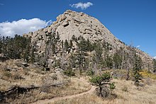
| Highest point | Greyrock Mountain summit 7,613 feet (2,320 m)[1] |
| Lowest point | Trailhead on Cache La Poudre river 5,574 feet (1,699 m)[1] |
| Difficulty | Moderate |
Greyrock Mountain National Recreation Trail is a hiking trail in Roosevelt National Forest west of Laporte, Colorado. The trail was constructed by the Civilian Conservation Corps in the 1930s[1] and designated as a National Recreation Trail in 1979.[2]

References
- ^ a b c d e "Greyrock Trail #946". Poudre Wilderness Volunteers. Archived from the original on 2013-01-31. Retrieved 2011-01-20.
- ^ "Greyrock Mountain Trail". National Recreation Trails Database.
40°41′43″N 105°17′7″W / 40.69528°N 105.28528°W / 40.69528; -105.28528
- v
- t
- e

| 43 State Parks |
|
|---|---|
| 1 State Forest | |
| 307 State Wildlife Areas | |
| 96 State Natural Areas |
|
| 26 Scenic and Historic Byways |
|
| 28 National Recreation Trails |
|
|---|---|
| 6 Regional Trails |


