Grade I listed buildings in Rutland

Map all coordinates using OpenStreetMap
Download coordinates as:
- KML
- GPX (all coordinates)
- GPX (primary coordinates)
- GPX (secondary coordinates)
There are over 9,000 Grade I listed buildings in England. This page is a list of the 28 of these buildings in the county of Rutland.
Rutland
| Name | Location | Type | Completed [note 1] | Date designated | Grid ref.[note 2] Geo-coordinates | Entry number [note 3] | Image |
|---|---|---|---|---|---|---|---|
| Church of St Mary | Ashwell | Church | 12th century | 14 June 1954 | SK8657213744 52°42′52″N 0°43′12″W / 52.71444°N 0.719892°W / 52.71444; -0.719892 (Church of St Mary) | 1073268 |  More images |
| Church of St Peter | Brooke | Parish Church | 12th century | 14 June 1954 | SK8497705724 52°38′33″N 0°44′44″W / 52.642612°N 0.745564°W / 52.642612; -0.745564 (Church of St Peter) | 1215370 |  More images |
| House, with wings, stables and colonnades | Burley-on-the-Hill | Country House | 1694-1705 | 18 September 1984 | SK8844710284 52°40′59″N 0°41′35″W / 52.683041°N 0.693073°W / 52.683041; -0.693073 (House, with wings, stables and colonnades) | 1073792 |  More images |
| Church of St Mary | Edith Weston | Church | C12-C14 | 14 June 1954 | SK9272305354 52°38′17″N 0°37′52″W / 52.63802°N 0.631224°W / 52.63802; -0.631224 (Church of St Mary) | 1073962 |  More images |
| Church of St Edmund | Egleton | Church | Norman | 14 June 1954 | SK8759407535 52°39′31″N 0°42′23″W / 52.658473°N 0.706418°W / 52.658473; -0.706418 (Church of St Edmund) | 1073761 | 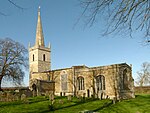 More images |
| Church of St Peter | Empingham | Church | C13-C15 | 14 June 1954 | SK9506408471 52°39′56″N 0°35′45″W / 52.665628°N 0.595744°W / 52.665628; -0.595744 (Church of St Peter) | 1073940 |  More images |
| Church of Saint Peter and Saint Paul | Exton Park, Exton | Parish Church | Medieval | 14 June 1954 | SK9205211192 52°41′26″N 0°38′22″W / 52.690601°N 0.639508°W / 52.690601; -0.639508 (Church of Saint Peter and Saint Paul) | 1177714 |  More images |
| Church of St Peter and St Paul | Great Casterton | Church | 13th century | 6 June 1961 | TF0013408796 52°40′03″N 0°31′15″W / 52.667637°N 0.520703°W / 52.667637; -0.520703 (Church of St Peter and St Paul) | 1073841 |  More images |
| Church of St Mary | Greetham | Church | Norman | 14 June 1954 | SK9245814651 52°43′18″N 0°37′57″W / 52.721619°N 0.632532°W / 52.721619; -0.632532 (Church of St Mary) | 1073218 |  More images |
| Church of St Mary | Ketton | Church | 12th century | 6 June 1961 | SK9818704298 52°37′39″N 0°33′03″W / 52.62757°N 0.550821°W / 52.62757; -0.550821 (Church of St Mary) | 1073856 |  More images |
| Church of St Peter and St Paul | Langham | Parish Church | Medieval | 14 June 1954 | SK8436711205 52°41′31″N 0°45′11″W / 52.691968°N 0.753175°W / 52.691968; -0.753175 (Church of St Peter and St Paul) | 1073732 |  More images |
| Church of St Andrew | Lyddington | Parish Church | Early/Mid 14th century | 10 November 1955 | SP8761296992 52°33′49″N 0°42′32″W / 52.563715°N 0.708941°W / 52.563715; -0.708941 (Church of St Andrew) | 1236656 |  More images |
| The Bede House | Lyddington | Bishop's Palace | Late C12/C13 | 10 November 1955 | SP8758797005 52°33′50″N 0°42′34″W / 52.563836°N 0.709306°W / 52.563836; -0.709306 (The Bede House) | 1264528 |  More images |
| Watch Tower | Lyddington | Gazebo | Late 15th century | 10 November 1955 | SP8754696952 52°33′48″N 0°42′36″W / 52.563366°N 0.709925°W / 52.563366; -0.709925 (Watch Tower) | 1236617 |  More images |
| Church of St Peter and St Paul | Market Overton | Parish church | Anglo-Saxon | 14 June 1954 | SK8858916453 52°44′18″N 0°41′22″W / 52.73846°N 0.689313°W / 52.73846; -0.689313 (Church of St Peter and St Paul) | 1073229 |  More images |
| Church of St Mary | Morcott | Parish Church | C12-C13 | 10 November 1955 | SK9246300786 52°35′49″N 0°38′11″W / 52.597011°N 0.636341°W / 52.597011; -0.636341 (Church of St Mary) | 1288037 |  More images |
| Church of St John the Baptist | North Luffenham | Church | C12-C15 | 10 November 1955 | SK9344003255 52°37′09″N 0°37′16″W / 52.619034°N 0.621225°W / 52.619034; -0.621225 (Church of St John the Baptist) | 1073898 |  More images |
| Luffenham Hall | North Luffenham | Manor House | Early C20 | 10 November 1955 | SK9352103231 52°37′08″N 0°37′12″W / 52.618804°N 0.620035°W / 52.618804; -0.620035 (Luffenham Hall) | 1073899 |  More images |
| Church of All Saints | Oakham | Parish Church | Early 13th century | 8 May 1950 | SK8606608905 52°40′16″N 0°43′43″W / 52.67103°N 0.728645°W / 52.67103; -0.728645 (Church of All Saints) | 1073305 |  More images |
| Oakham Castle | Oakham | Castle | 1180-90 | 8 May 1950 | SK8614708895 52°40′15″N 0°43′39″W / 52.670927°N 0.72745°W / 52.670927; -0.72745 (Oakham Castle) | 1073277 |  More images |
| Gateway to Oakham Castle | Oakham | Gateway | 24 November 1971 | SK8615308850 52°40′14″N 0°43′39″W / 52.670522°N 0.727373°W / 52.670522; -0.727373 (Gateway to Oakham Castle) | 1361781 | 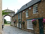 More images | |
| Market Cross | Oakham | Market Cross | 17th century | 8 May 1950 | SK8609908829 52°40′13″N 0°43′41″W / 52.670342°N 0.728177°W / 52.670342; -0.728177 (Market Cross) | 1073278 |  More images |
| Stocks | Oakham | Stocks | 8 May 1950 | SK8610508827 52°40′13″N 0°43′41″W / 52.670323°N 0.728088°W / 52.670323; -0.728088 (Stocks) | 1073279 |  More images | |
| Church of St John | Ryhall | Church | c. 1200 | 6 June 1961 | TF0362410820 52°41′07″N 0°28′07″W / 52.685171°N 0.468478°W / 52.685171; -0.468478 (Church of St John) | 1320352 |  More images |
| Church of St Andrew | Stoke Dry | Parish Church | Early 12th century | 10 November 1955 | SP8555296768 52°33′43″N 0°44′22″W / 52.562029°N 0.739381°W / 52.562029; -0.739381 (Church of St Andrew) | 1237061 |  More images |
| Church of St Peter | Tickencote | Church | 12th century | 14 June 1954 | SK9904409492 52°40′27″N 0°32′12″W / 52.674092°N 0.536606°W / 52.674092; -0.536606 (Church of St Peter) | 1115498 |  More images |
| Elizabethan School Room, Uppingham School | Uppingham | School | 1584 | 10 November 1955 | SP8670099591 52°35′14″N 0°43′18″W / 52.58722°N 0.721713°W / 52.58722; -0.721713 (Elizabethan School Room, Uppingham School) | 1073171 |  |
| Church of St Andrew | Whissendine | Church | C13-C15 | 14 June 1954 | SK8331214309 52°43′12″N 0°46′05″W / 52.720029°N 0.767995°W / 52.720029; -0.767995 (Church of St Andrew) | 1295308 |  More images |
Notes
- ^ The date given is the date used by Historic England as significant for the initial building or that of an important part in the structure's description.
- ^ Sometimes known as OSGB36, the grid reference is based on the British national grid reference system used by the Ordnance Survey.
- ^ The "List Entry Number" is a unique number assigned to each listed building and scheduled monument by Historic England.
References
English Heritage Images of England
External links
![]() Media related to Grade I listed buildings in Rutland at Wikimedia Commons
Media related to Grade I listed buildings in Rutland at Wikimedia Commons
- v
- t
- e
- Bedfordshire
- Berkshire
- Bristol
- Buckinghamshire
- Cambridgeshire
- Cheshire
- Cornwall
- Cumbria
- Derbyshire
- Devon
- Dorset
- Durham
- East Sussex
- East Riding of Yorkshire
- Essex
- Gloucestershire
- Greater London
- Greater Manchester
- Hampshire
- Herefordshire
- Hertfordshire
- Isle of Wight
- Kent
- Lancashire
- Leicestershire
- Lincolnshire
- Merseyside
- Norfolk
- North Yorkshire
- Northamptonshire
- Northumberland
- Nottinghamshire
- Oxfordshire
- Rutland
- Shropshire
- Somerset
- South Yorkshire
- Staffordshire
- Suffolk
- Surrey
- Tyne and Wear
- Warwickshire
- West Midlands
- West Sussex
- West Yorkshire
- Wiltshire
- Worcestershire
- Babergh
- Bath and North East Somerset
- Bradford
- Brighton and Hove
- Broadland
- Cheltenham
- Cheshire East
- Cheshire West and Chester
- Cotswold
- Craven
- Dartford
- Dover
- Forest Heath
- Forest of Dean
- Ipswich
- Maidstone
- Mendip
- Mid Suffolk
- North Somerset
- Sedgemoor
- South Gloucestershire
- South Somerset
- St Edmundsbury
- Stroud
- Suffolk Coastal
- Taunton Deane
- Tewkesbury
- Waveney
- West Somerset
- Churches
- War memorials
- 20th century


