Grade II* listed buildings in Epsom and Ewell

Map all coordinates using OpenStreetMap
Download coordinates as:
- KML
- GPX (all coordinates)
- GPX (primary coordinates)
- GPX (secondary coordinates)
There are over 20,000 Grade II* listed buildings in England. This page is a list of the 17 Grade II* listed buildings in the district of Epsom and Ewell in Surrey. For links to similar articles in relation to the other 10 districts of Surrey see Grade II* listed buildings in Surrey.
| Name | Location | Type | Completed [note 1] | Date designated | Grid ref.[note 2] Geo-coordinates | Entry number [note 3] | Image |
|---|---|---|---|---|---|---|---|
| Ashley House | Epsom | House | Dated 1769 | 10 April 1954 | TQ2081160675 51°19′56″N 0°16′02″W / 51.332345°N 0.267261°W / 51.332345; -0.267261 (Ashley House) | 1289636 |  Upload Photo |
| Christ Church | Epsom Common | Church | 1876 | 22 March 1974 | TQ1954660880 51°20′04″N 0°17′07″W / 51.334455°N 0.285342°W / 51.334455; -0.285342 (Christ Church) | 1289540 |  More images |
| Curved Colonnades, Entrance Steps, Outer Pavilions of Woodcote Park (old House), Woodcote Park | Woodcote Park | House | Underway in 1753 | 10 April 1954 | TQ2028958769 51°18′55″N 0°16′31″W / 51.315325°N 0.275393°W / 51.315325; -0.275393 (Curved Colonnades, Entrance Steps, Outer Pavilions of Woodcote Park (old House), Woodcote Park) | 1288718 | 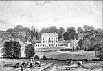 More images |
| Ebbisham House | Epsom | Early 18th century | 10 April 1954 | TQ2133360425 51°19′48″N 0°15′35″W / 51.329987°N 0.259857°W / 51.329987; -0.259857 (Ebbisham House) | 1378229 |  | |
| Forecourt Rails to Hylands House & Hylands House | Epsom | House | c. 1740 | 10 April 1954 | TQ2022659907 51°19′32″N 0°16′33″W / 51.325566°N 0.275913°W / 51.325566; -0.275913 (Forecourt Rails to Hylands House & Hylands House) | 1044740 | Upload Photo |
| Garden Wall to Green Anne House, Queen Anne House & Woodcote End House | Epsom and Ewell | House | Late C17-early 18th century | 10 April 1954 | TQ2067759971 51°19′34″N 0°16′10″W / 51.326046°N 0.269422°W / 51.326046; -0.269422 (Garden Wall to Green Anne House, Queen Anne House & Woodcote End House) | 1288644 | Upload Photo |
| The Durdans | Epsom and Ewell | House | 1764 | 10 January 1974 | TQ2078059452 51°19′17″N 0°16′05″W / 51.32136°N 0.26812°W / 51.32136; -0.26812 (The Durdans) | 1378221 |  More images |
| Gates to the Durdans on Chalk Lane | Epsom and Ewell | Gate | Early 18th century | 10 April 1954 | TQ2089659517 51°19′19″N 0°15′59″W / 51.321919°N 0.266434°W / 51.321919; -0.266434 (Gates to the Durdans on Chalk Lane) | 1378222 | 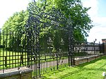 |
| Riding School at the Durdans | Epsom and Ewell | Riding School | 1881 | 10 January 1974 | TQ2085759581 51°19′21″N 0°16′01″W / 51.322503°N 0.266972°W / 51.322503; -0.266972 (Riding School at the Durdans) | 1378224 |  More images |
| Nonsuch Park House | Nonsuch Park | Country House | 1802-1806 | 10 April 1954 | TQ2342663611 51°21′29″N 0°13′43″W / 51.358171°N 0.228728°W / 51.358171; -0.228728 (Nonsuch Park House) | 1378198 |  More images |
| Parish Church of St Martin | Epsom and Ewell | Parish Church | c. 1450 | 10 April 1954 | TQ2139560522 51°19′51″N 0°15′32″W / 51.330846°N 0.258935°W / 51.330846; -0.258935 (Parish Church of St Martin) | 1028592 | 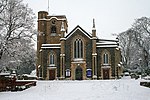 More images |
| The Cedars | Epsom | House | late C17-early 18th century | 10 April 1954 | TQ2121660598 51°19′54″N 0°15′41″W / 51.331567°N 0.261477°W / 51.331567; -0.261477 (The Cedars) | 1378227 | Upload Photo |
| The Hylands, Including Forecourt Walls, Piers, Clairvoyee and Gates | Epsom and Ewell | House | Mid 18th century | 10 April 1954 | TQ2025259943 51°19′33″N 0°16′32″W / 51.325885°N 0.275528°W / 51.325885; -0.275528 (The Hylands, Including Forecourt Walls, Piers, Clairvoyee and Gates) | 1044739 | Upload Photo |
| Woodcote Green House | Epsom and Ewell | House | Late 17th century | 10 April 1954 | TQ2066759851 51°19′30″N 0°16′11″W / 51.32497°N 0.269606°W / 51.32497; -0.269606 (Woodcote Green House) | 1214289 | Upload Photo |
| Woodcote Grove | Epsom and Ewell | House | Late 17th century | 10 April 1954 | TQ2083059762 51°19′27″N 0°16′02″W / 51.324135°N 0.267298°W / 51.324135; -0.267298 (Woodcote Grove) | 1028576 |  |
| 149–153 High Street | Epsom and Ewell | Tenement House | C20 | 10 April 1954 | TQ2062460705 51°19′58″N 0°16′12″W / 51.332654°N 0.269934°W / 51.332654; -0.269934 (149–153 High Street) | 1213183 |  More images |
| 127 and 129 High Street | Epsom and Ewell | House | Late 18th century | 10 April 1954 | TQ2070860725 51°19′58″N 0°16′07″W / 51.332816°N 0.268722°W / 51.332816; -0.268722 (127 and 129 High Street) | 1213163 | Upload Photo |
Notes
- ^ The date given is the date used by Historic England as significant for the initial building or that of an important part in the structure's description.
- ^ Sometimes known as OSGB36, the grid reference is based on the British national grid reference system used by the Ordnance Survey.
- ^ The "List Entry Number" is a unique number assigned to each listed building and scheduled monument by Historic England.
References
English Heritage Images of England


