God's Pocket Marine Provincial Park
Park in British Columbia, Canada
50°50′14″N 127°33′39″W / 50.83722°N 127.56083°W / 50.83722; -127.56083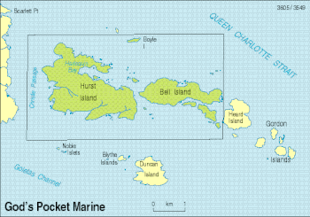
God's Pocket Marine Provincial Park is a provincial park in southwest British Columbia, Canada, established on July 12, 1995. It is well known as a cold water scuba diving and kayaking destination.[1] The park is 2,036 hectares in size,[2] and includes two main islands, Hurst and Bell islands, respectively, and many smaller isles.[citation needed]
References
- BC Parks - God's Pocket Marine Provincial Park
- v
- t
- e
- CRHP
- Alberni-Clayoquot RD
- BC Coast
- Capital RD
- Kootenay RD
- Columbia-Shuswap RD
- Comox Valley RD
- Cowichan Valley RD
- East Kootenay RD
- Fraser Valley RD
- Kootenay Boundary RD
- Nanaimo RD
- New Westminster
- North Okanagan RD
- North Shore
- Northern/Central BC Interior
- Okanagan-Similkameen RD
- Squamish-Lillooet RD
- Strathcona RD
- Surrey
- Thompson-Nicola RD
- Vancouver
- Victoria
| |||||
| |||||||
| |||||
| |||||
Wildlife Management Areas | |
|---|---|
|
Other | |
|---|---|
|
 Category
- BC Parks
 Commons

50°50′19″N 127°33′54″W / 50.83861°N 127.56500°W / 50.83861; -127.56500
 | This British Columbia protected areas related article is a stub. You can help Wikipedia by expanding it. |
- v
- t
- e


