Garnahovit
Place in Aragatsotn, Armenia
Garnahovit Գառնահովիտ | |
|---|---|
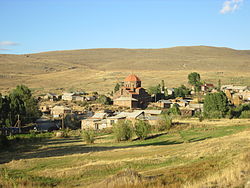 The village of Garnahovit with the imposing Church of S. Gevorg (center). | |
40°29′50″N 43°57′20″E / 40.49722°N 43.95556°E / 40.49722; 43.95556 | |
| Country | Armenia |
| Province | Aragatsotn |
| Municipality | Talin |
| Area | |
| • Total | 0.47 km2 (0.18 sq mi) |
| Elevation | 2,136 m (7,008 ft) |
| Population (2001) | |
| • Total | 440 |
| • Density | 940/km2 (2,400/sq mi) |
| Time zone | UTC+4 (GMT+4) |
Garnahovit (Armenian: Գառնահովիտ) is a village in the Talin Municipality of the Aragatsotn Province of Armenia. The village has an imposing mid-7th century church of S. Gevorg. There are other church remains in the gorge to the east and Urartian remains nearby to the east and southeast.[1]
References
- ^ Kiesling, Brady (June 2000). Rediscovering Armenia: An Archaeological/Touristic Gazetteer and Map Set for the Historical Monuments of Armenia (PDF). Archived (PDF) from the original on 6 November 2021.
- Garnahovit at GEOnet Names Server
- Report of the results of the 2001 Armenian Census
- v
- t
- e
 Aragatsotn Province
Capital: Ashtarak
- Aparan
- Ashtarak
- Talin

 | This article about a location in Aragatsotn Province, Armenia is a stub. You can help Wikipedia by expanding it. |
- v
- t
- e


