El Qanater El Khayreya
Place in Qalyubia, Egypt
El Qanater El Khayreya القناطر الخيرية | |
|---|---|
 | |
| 30°11′37″N 31°07′55″E / 30.193583°N 31.132064°E / 30.193583; 31.132064 | |
| Country |  Egypt Egypt |
| Governorate | Qalyubia |
| Time zone | UTC+2 (EST) |
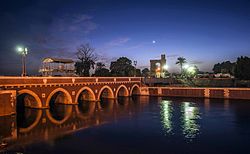
El Qanater El Khayreya (Arabic: القناطر الخيرية pronounced [elʔɑˈnɑːtˤeɾ elxæjˈɾejjæ], "the Benevolent Bridges") is a city and a markaz in Qalyubia Governorate, Egypt. It is the location of the Delta Barrages, the first modern irrigation structure across the Nile, located at the apex of the Nile Delta. In the mid 1850s, when Viceroy Sa'id Pasha took over project construction, he ordered a silver medal to be struck to mark the occasion. He then ordered the construction of a town near the incomplete barrage. Again the project would be bogged down due to financial problems; the original barrages were initially completed in 1862. A new barrage structure was built slightly downstream in 1939.[1] The name of the city is a reference to the structure and the river crossing it.[2]
Geography
Climate
Köppen climate classification system classifies its climate as hot desert (BWh),[3] as the rest of Egypt.
| Climate data for El Qanater el Khayreyya | |||||||||||||
|---|---|---|---|---|---|---|---|---|---|---|---|---|---|
| Month | Jan | Feb | Mar | Apr | May | Jun | Jul | Aug | Sep | Oct | Nov | Dec | Year |
| Mean daily maximum °C (°F) | 19.4 (66.9) | 20.9 (69.6) | 23.6 (74.5) | 27.9 (82.2) | 31.9 (89.4) | 34.3 (93.7) | 34.6 (94.3) | 34.4 (93.9) | 32.2 (90.0) | 30 (86) | 25.4 (77.7) | 21 (70) | 28.0 (82.4) |
| Daily mean °C (°F) | 13 (55) | 13.9 (57.0) | 16.5 (61.7) | 19.9 (67.8) | 23.8 (74.8) | 26.4 (79.5) | 27.5 (81.5) | 27.4 (81.3) | 25.2 (77.4) | 23.1 (73.6) | 19.1 (66.4) | 14.8 (58.6) | 20.9 (69.6) |
| Mean daily minimum °C (°F) | 6.6 (43.9) | 7 (45) | 9.4 (48.9) | 12 (54) | 15.7 (60.3) | 18.5 (65.3) | 20.5 (68.9) | 20.4 (68.7) | 18.3 (64.9) | 16.2 (61.2) | 12.9 (55.2) | 8.6 (47.5) | 13.8 (57.0) |
| Average precipitation mm (inches) | 4 (0.2) | 5 (0.2) | 3 (0.1) | 1 (0.0) | 1 (0.0) | 0 (0) | 0 (0) | 0 (0) | 0 (0) | 1 (0.0) | 2 (0.1) | 5 (0.2) | 22 (0.8) |
| Source: Climate-Data.org (altitude: 18m)[3] | |||||||||||||
References
- v
- t
- e
Giza, 6th of October City, Sheikh Zayed City, El Hawamdeya, El Badrashein, El Saff, Atfih, El Ayyat, Bawiti, Manshiyat al Qanater, Awsim, Kerdasa, Abu El Numrus
Benha, Qalyub, Shubra El Kheima, El Qanater El Khayreya, Khanka, Kafr Shukr, Toukh, Qaha, Obour City, Khusus, Shibin El Qanater, Saryaqos, El Kulzom
Damanhur, Kafr El Dawwar, Rosetta, Edku, Abu El Matamir, Abu Hummus, El Delengat, El Mahmoudiyah, El Rahmaniya, Itay El Barud, Hosh Issa, Shubra Khit, Koum Hamada, Badr, Wadi El Natrun, New Nubariya
Mansoura, Talkha, Mit Ghamr, Dekernes, Aga, Minyat An-Nasr, El Senbellawein, El Kurdi, Bani Ebaid, El Manzala, Temay El Amdeed, El Gammalia, Sherbin, El Matareya, Dakahlia, Belqas, Mit Salsil, Gamasa, Mahallat Damana, Nabaruh
Kafr El Sheikh, Desouk, Fuwwah, Metoubes, Baltim, El Hamool, Biyala, El Reyad, Sidi Salem, Qallin, Sidi Ghazi, Borg El Burulus
Shibin El Kom, Sadat (city), Menouf, Sirs Al-Layyan, Ashmoun, El Bagour, Quesna, Birket El Sab, Tala, Shuhada
Zagazig, 10th of Ramadan (city), Minya El Qamh, Bilbeis, Mashtool El Souk, Al-Qinayat, Abu Hammad, El Qurein, Hihya, Abu Kebir, Faqous, El Salheya El Gedida, El Ibrahimiya, Diyarb Negm, Kafr Saqr, Awlad Saqr, El Husseiniya, Tanis, Minshat Abu Omar, Qantir
Minya, New Minya, El Idwa, Maghagha, Beni Mazar, Matai, Samalut, Mallawi, Dir Mawas, Aba al-Waqf, Dir Mawas, Dalga, Bahnasa, Idmo, Tuna el-Gebel, Al Madinah Al Fikriyyah
Sohag, New Sohag, Akhmim, New Akhmim, El Balyana, El Maragha, Ptolemais Hermiou, Dar El Salam, Girga, West Juhayna, Saqultah, Tima, Tahta
Capital cities are in bold font.
 | This geography of Egypt article is a stub. You can help Wikipedia by expanding it. |
- v
- t
- e


