Cochapeti District
District in Ancash, Peru
Cochapeti Quchap'iti | |
|---|---|
District | |
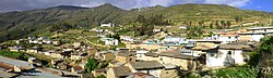 Skyline | |
| Country |  Peru Peru |
| Region | Ancash |
| Province | Huarmey |
| Founded | March 5, 1936 |
| Capital | Cochapeti |
| Government | |
| • Mayor | Ing. Faustina Vilma Caro Soto |
| Area | |
| • Total | 100.02 km2 (38.62 sq mi) |
| Elevation | 3,498 m (11,476 ft) |
| Population (2005 census) | |
| • Total | 957 |
| • Density | 9.6/km2 (25/sq mi) |
| Time zone | UTC-5 (PET) |
| UBIGEO | 021102 |
Cochapeti District is one of five districts of the province Huarmey in Peru.[1]
References
- ^ (in Spanish) Instituto Nacional de Estadística e Informática. Banco de Información Distrital Archived April 23, 2008, at the Wayback Machine. Retrieved April 11, 2008.
- v
- t
- e
 Districts of Ancash Region, Peru
9°58′59″S 77°39′00″W / 9.98306°S 77.65000°W / -9.98306; -77.65000
 | This Ancash Region geography article is a stub. You can help Wikipedia by expanding it. |
- v
- t
- e


