Chadual
Village in Rajasthan, India
24°54′43″N 72°38′49″E / 24.91194°N 72.64694°E / 24.91194; 72.64694 India
IndiaChadual is a village in Sirohi district in the Indian state of Rajasthan
Geography
It is located about 25 km west of Sirohi.[1]
Demographics
This village has many castes including Purohit, Rawal Brahmin, Rajput, Jain, Suthar, Mali, Prajapat, Bhatt Brahmin, Dewasi, Boda Prajapat, Meghwal and Bheel.
Governance
This village is represented by the Govt. Local Body Gram Panchayat tanwari.[how?]
Culture
This village has many Hindu temples and also one Jain temple.
Gallery
-
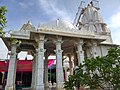 Shri Vaijnath Mahadev Temple in Chadual
 -
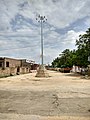 Chadual Bus Station


References
- ^ "Pin code Chadual". Pin code india. Retrieved 27 March 2017.
- v
- t
- e
Cities and towns in Sirohi district
towns
- Abu Road
- Dabani
- Mount Abu
- Pindwara
- Reodar
- Sheoganj
- Sirohi (district headquarters)
 | This article related to a location in Rajasthan is a stub. You can help Wikipedia by expanding it. |
- v
- t
- e


