Brodersby, Rendsburg-Eckernförde
Municipality in Schleswig-Holstein, Germany

Coat of arms
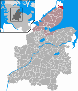
Location of Brodersby within Rendsburg-Eckernförde district
54°37′N 9°58′E / 54.617°N 9.967°E / 54.617; 9.967
(2022-12-31)[1]
24398
ostsee.de
Brodersby is a municipality in the district of Rendsburg-Eckernförde, in Schleswig-Holstein, Germany.
History
Brodersby and Höxmark were first mentioned in 1268. In 1876 Brodersby became an independent rural municipality of Rendsburg-Eckernförde.
Geography and Transport
The Ostseebad Schönhagen with a sandy beach and its steep coast is the largest place in the municipality. In addition, Brodersby, Dingelby, Drasberg, Höxmark (Danish: Høgsmark ), Langacker ( Langager ), Lückeberg and Nübbelfeld ( Nybølmark ) belong to it. The localities Nordhusene and Kikut ( Kikud ) have meanwhile opened up in the Schönhagen district. To the west is the Schwansenstraßefrom Kappeln to Eckernförde, in the south the community extends to Schwansener See.
Climate
| Climate data for Schönhagen (1991–2020 normals) | |||||||||||||
|---|---|---|---|---|---|---|---|---|---|---|---|---|---|
| Month | Jan | Feb | Mar | Apr | May | Jun | Jul | Aug | Sep | Oct | Nov | Dec | Year |
| Mean daily maximum °C (°F) | 4.4 (39.9) | 4.3 (39.7) | 7.1 (44.8) | 11.2 (52.2) | 15.6 (60.1) | 19.1 (66.4) | 21.4 (70.5) | 21.0 (69.8) | 17.8 (64.0) | 13.1 (55.6) | 8.7 (47.7) | 5.5 (41.9) | 12.5 (54.5) |
| Daily mean °C (°F) | 2.3 (36.1) | 2.3 (36.1) | 4.3 (39.7) | 7.6 (45.7) | 11.7 (53.1) | 15.2 (59.4) | 17.5 (63.5) | 17.4 (63.3) | 14.8 (58.6) | 10.8 (51.4) | 6.7 (44.1) | 3.7 (38.7) | 9.5 (49.1) |
| Mean daily minimum °C (°F) | 0.3 (32.5) | 0.2 (32.4) | 1.6 (34.9) | 4.1 (39.4) | 7.7 (45.9) | 11.2 (52.2) | 13.3 (55.9) | 13.7 (56.7) | 11.2 (52.2) | 8.1 (46.6) | 4.4 (39.9) | 1.7 (35.1) | 6.3 (43.3) |
| Average precipitation mm (inches) | 133.6 (5.26) | 104.1 (4.10) | 106.0 (4.17) | 73.4 (2.89) | 96.5 (3.80) | 90.9 (3.58) | 129.9 (5.11) | 96.2 (3.79) | 111.0 (4.37) | 110.9 (4.37) | 119.7 (4.71) | 142.5 (5.61) | 1,313.3 (51.70) |
| Average relative humidity (%) | 89.5 | 86.4 | 85.1 | 81.7 | 81.1 | 81.1 | 81.1 | 83.3 | 84.4 | 86.0 | 89.1 | 89.7 | 84.9 |
| Mean monthly sunshine hours | 42.4 | 64.4 | 132.2 | 220.8 | 253.2 | 245.0 | 239.7 | 210.9 | 167.4 | 111.4 | 55.9 | 34.2 | 1,769.9 |
| Source: World Meteorological Organization[2] | |||||||||||||
Politics
Community Council
Of the nine seats in the municipal council, the CDU had five seats since the local elections in 2003 and the SPD had four.
Of the nine seats in the municipal council, the CDU had six seats since the 2008 local elections and the SPD three.
Of the twelve seats in the municipal council, the CDU has had six seats since the local elections in Schleswig-Holstein on May 26, 2013, the SPD three and the voting community “Democratic Initiative” also has three seats.
Coat of arms
Blazon: "In gold, a raised, curved blue tip. At the top right a three-leaved green oak branch, at the top left three fanned green ears. At the bottom a silver swan over five silver wavy threads."[3]
Economy
Agriculture is one of the main industries of Brodersby, in addition to agriculture, tourism is an important source of income, especially in Schönhagen with its spa center and hotels.
Schloss Schönhagen
Castle Schönhagen was created in 1711 near a farm in Höxmark. The eponymous manor district existed until 1928.
Built in 1889 by the Hanseatic Nobleman Hermann Jauch, it was used as his primary residence until his death, today the castle is used as a rehabilitation clinic.
Pictures
-
 Schloss Schönhagen
 -
 Street in Brodersby
 -
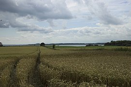 Schwansener See
 -
 View from the top of a cliff in Schönhagen
 -
 Cliff Schönhagen


External links
Wikimedia Commons has media related to Brodersby (Schwansen).
- Municipality of Brodersby at the office of Schlei-Ostsee
- Touristinformation Schönhagen
- v
- t
- e
Towns and municipalities in Rendsburg-Eckernförde
- Achterwehr
- Ahlefeld-Bistensee
- Alt Duvenstedt
- Altenhof
- Altenholz
- Arpsdorf
- Ascheffel
- Aukrug
- Bargstall
- Bargstedt
- Barkelsby
- Beldorf
- Bendorf
- Beringstedt
- Bissee
- Blumenthal
- Böhnhusen
- Bokel
- Bordesholm
- Borgdorf-Seedorf
- Borgstedt
- Bornholt
- Bovenau
- Brammer
- Bredenbek
- Breiholz
- Brekendorf
- Brinjahe
- Brodersby
- Brügge
- Büdelsdorf
- Bünsdorf
- Christiansholm
- Damendorf
- Damp
- Dänischenhagen
- Dätgen
- Dörphof
- Eckernförde
- Ehndorf
- Eisendorf
- Ellerdorf
- Elsdorf-Westermühlen
- Embühren
- Emkendorf
- Felde
- Felm
- Fleckeby
- Flintbek
- Fockbek
- Friedrichsgraben
- Friedrichsholm
- Gammelby
- Gettorf
- Gnutz
- Gokels
- Goosefeld
- Grauel
- Grevenkrug
- Groß Buchwald
- Groß Vollstedt
- Groß Wittensee
- Güby
- Haale
- Haby
- Hamdorf
- Hamweddel
- Hanerau-Hademarschen
- Haßmoor
- Heinkenborstel
- Hoffeld
- Hohenwestedt
- Hohn
- Holtsee
- Holzbunge
- Holzdorf
- Hörsten
- Hummelfeld
- Hütten
- Jahrsdorf
- Jevenstedt
- Karby
- Klein Wittensee
- Königshügel
- Kosel
- Krogaspe
- Kronshagen
- Krummwisch
- Langwedel
- Lindau
- Lohe-Föhrden
- Loop
- Loose
- Luhnstedt
- Lütjenwestedt
- Meezen
- Melsdorf
- Mielkendorf
- Molfsee
- Mörel
- Mühbrook
- Negenharrie
- Neudorf-Bornstein
- Neu Duvenstedt
- Neuwittenbek
- Nienborstel
- Nindorf
- Noer
- Nortorf
- Nübbel
- Oldenbüttel
- Oldenhütten
- Osdorf
- Ostenfeld
- Osterby
- Osterrönfeld
- Osterstedt
- Ottendorf
- Owschlag
- Padenstedt
- Prinzenmoor
- Quarnbek
- Rade bei Hohenwestedt
- Rade bei Rendsburg
- Reesdorf
- Remmels
- Rendsburg
- Rickert
- Rieseby
- Rodenbek
- Rumohr
- Schacht-Audorf
- Schierensee
- Schinkel
- Schmalstede
- Schönbek
- Schönhorst
- Schülldorf
- Schülp bei Nortorf
- Schülp bei Rendsburg
- Schwedeneck
- Seefeld
- Sehestedt
- Sophienhamm
- Sören
- Stafstedt
- Steenfeld
- Strande
- Tackesdorf
- Tappendorf
- Techelsdorf
- Thaden
- Thumby
- Timmaspe
- Todenbüttel
- Tüttendorf
- Waabs
- Wapelfeld
- Warder
- Wasbek
- Wattenbek
- Westensee
- Westerrönfeld
- Windeby
- Winnemark

References
- ^ "Bevölkerung der Gemeinden in Schleswig-Holstein 4. Quartal 2022" (XLS) (in German). Statistisches Amt für Hamburg und Schleswig-Holstein.
- ^ "World Meteorological Organization Climate Normals for 1991–2020". World Meteorological Organization Climatological Standard Normals (1991–2020). National Oceanic and Atmospheric Administration. Archived from the original on 12 October 2023. Retrieved 13 October 2023.
- ^ 1044 Municipal heraldic roll of Schleswig-Holstein
Authority control databases | |
|---|---|
| International |
|
| National |
|
 | This Rendsburg-Eckernförde location article is a stub. You can help Wikipedia by expanding it. |
- v
- t
- e


