Botusfleming
Human settlement in England


Botus Fleming
Location within Cornwall
- Botus Fleming
- Cornwall
- Cornwall
- South West
- South East Cornwall
Botus Fleming or Botusfleming (Cornish: Bosflumyes) is a village and civil parish in southeast Cornwall, England, United Kingdom.[1] The 2001 census gives the parish population as 783,which decreased to 771 at the 2011 census.[2] The village is about three miles north-west of Saltash at grid reference SX 403 612. There is a public house (the Rising Sun), a market garden and a small colony of artists, but the village is mostly a dormitory area for Plymouth.
Parish church
The parish church is dedicated to St Mary and has a western tower and a fine arcade between the nave and the north aisle. The church was restored in 1872 by Henry Eliott; this restoration included new roofs, floors, pews and glazing. The font is of Polyphant stone, probably 14th century in date. In a field near the church is an obelisk in memory of William Martyn built in 1762.[3]
In the church is a stone effigy of a knight in armour; he is thought to be Stephen le Fleming who was a medieval Crusader and perhaps left his name to the place.[4]
Other buildings
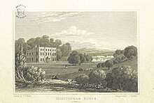
- Moditonham House is the site of the medieval castle of the Moditons and is now a large Georgian house which is a grade two* listed building incorporating fabric from the earlier building.[5][6] Michael Loam, a Cornish engineer who introduced the first man engine (a device to carry men up and down the shaft of a mine) into the UK died here.
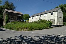
- The Bidwell is a 20th-century restored 14th century constructed well (with a roof) on a main street in the village, with a 19th-century statue of Saint Mary (mother of Jesus).[7]
- The Rising Sun pub was voted number 5 in Britain's Good Pub Guide 2009.
References
- ^ Ordnance Survey: Landranger map sheet 201 Plymouth & Launceston ISBN 978-0-319-23146-3
- ^ "parish population 2011". Retrieved 9 February 2015.
- ^ Beacham, Peter & Pevsner, Nikolaus (2014). Cornwall. New Haven: Yale University Press. ISBN 978-0-300-12668-6; p. 112
- ^ Mee, Arthur, ed. (1937) Cornwall. (The King's England.) London: Hodder & Stoughton; pp. 33-34
- ^ Pevsner, N. (1970) Cornwall; 2nd ed., revised by E. Radcliffe. Penguin; p. 44-45
- ^ "Moditonham House, Botusfleming". British Listed Buildings. Retrieved 17 June 2013.
- ^ Historic England. "Details from listed building database (1137879)". National Heritage List for England. Retrieved 28 March 2016.
External links
 Cornwall portal

![]() Media related to Botusfleming at Wikimedia Commons
Media related to Botusfleming at Wikimedia Commons
- v
- t
- e

Cornwall Portal
(cities in italics)
- Bodmin
- Bude
- Callington
- Camborne
- Camelford
- Falmouth
- Fowey
- Hayle
- Helston
- Hugh Town
- Launceston
- Liskeard
- Looe
- Lostwithiel
- Marazion
- Newlyn
- Newquay
- Padstow
- Penryn
- Penzance
- Porthleven
- Redruth
- St Austell
- St Blazey
- St Columb Major
- St Ives
- St Just in Penwith
- Saltash
- Stratton
- Torpoint
- Truro
- Wadebridge
See also: List of civil parishes in Cornwall
Civil parishes of South East Cornwall constituency | ||
|---|---|---|
|  | |
Cornwall Portal | ||


