Black Balsam Knob
35°19′40″N 82°52′27″W / 35.3278842°N 82.8742978°W / 35.3278842; -82.8742978[2]Geography Location Haywood County, North Carolina, U.S. Parent range Great Balsam Mountains
Blue Ridge Mountains Topo map USGS Shining Rock Climbing Easiest route Hike 
Blue Ridge Mountains
Black Balsam Knob,[2] also known as Black Balsam Bald, is in the Pisgah National Forest southwest of Asheville, North Carolina, near milepost 420 on the Blue Ridge Parkway. It is the second highest mountain[3] in the Great Balsam Mountains. The Great Balsams are within the Blue Ridge Mountains, which are part of the Appalachian Mountains. It is the 23rd highest of the 40 mountains in North Carolina over 6000 feet.[4]
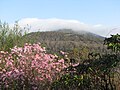
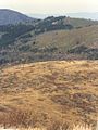
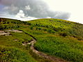
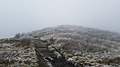
The top of the mountain is a grassy bald that affords a panoramic view. The origin of grassy balds in southern Haywood county is a result of extensive clear-cut logging and locomotive fires in 1925 and 1942.[5] These fires burned deep down into the mineral-rich topsoil slowing reforestation or stopping it altogether.[citation needed] Examples of this can also be found on many of its neighboring peaks and ridges. These features contribute to the area's popularity, but foot traffic also causes some ecological damage to the ecosystem. The Art Loeb Trail follows the grassy ridge of Black Balsam Knob.
Visible peaks from Black Balsam Knob include:
- Shining Rock in the Shining Rock Wilderness (3 miles northeast)
- Looking Glass Rock (5 miles southeast)
- Cold Mountain (6 miles north)
- Mount Pisgah (9.5 miles northeast)
- Mount Mitchell. On exceptionally clear days, Mount Mitchell, the highest point in the Eastern United States, is visible 45 miles north east.
Gallery
-
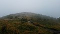
 View of summit of Black Balsam Knob covered by early morning spring haze.
 -
 On summit of Black Balsam Knob during early morning spring haze.
 -
 Shining Rock 3 miles in the distance as seen from Black Balsam Knob.
 -
 Looking Glass Rock 5 miles in the distance as seen from Black Balsam Knob.
 -
 Mount Pisgah 9.5 miles in the distance as seen from Black Balsam Knob.
 -
 View from Black Balsam Knob
 -
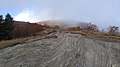
 Summit of Black Balsam Knob
 - Balsam Knob Mountain area aerial footage by a drone.
-
 Black Balsam in the Fall
 -
 Black Balsam in late Summer
 -
 Panorama in the Fall
 -
 View at Black Balsam
 -
 View from the peak of Black Balsam


See also
References
- ^ a b "Black Balsam Knob, North Carolina". Peakbagger.com. Retrieved 2007-07-09.
- ^ a b "Black Balsam Knob". Geographic Names Information System. United States Geological Survey, United States Department of the Interior. Retrieved 2013-01-29.
- ^ "Southern Appalachian 6000-foot Peaks". Peakbagger.com. Retrieved 2007-07-09.
- ^ "The Tallest Mountains in the Eastern U.S." Archived from the original on 2007-06-30. Retrieved 2007-07-09.
- ^ "Northcarolinaoutdoors.com". Northcarolinaoutdoors.com. Archived from the original on 2012-04-15. Retrieved 2012-08-23.
Wikimedia Commons has media related to Black Balsam Knob.
- v
- t
- e
| Bald Mountains | |
|---|---|
| Black Mountains |
|
| Brushy Mountains | |
| Great Balsam Mountains |
|
| Great Craggy Mountains | |
| Great Smoky Mountains | |
| Plott Balsams | |
| Unaka Range |
|
| Unicoi Mountains | |
| Iron Mountains |
|
| Others |
|
- Moore's Knob
- Pilot Mountain
- Albert Mountain
- Big Butt Mountain
- Cane Creek Mountains
- Crowders Mountain
- Devil's Courthouse
- Kings Pinnacle
- Looking Glass Rock
- Mayfield Mountain
- McAlpine Mountain
- Mount Jefferson
- Mulatto Mountain
- Occoneechee Mountain
- Old Butt Knob
- South Mountains
- Standing Indian Mountain
- Terrells Mountain
- Wayah Bald
- Wesser Bald
- Whiteside Mountain


