Bishopstone, Buckinghamshire
Human settlement in England
- Buckinghamshire
- Buckinghamshire
- South East
- Buckingham
- List of places
- UK
- England
- Buckinghamshire
Bishopstone is a small, rural village in the civil parish of Stone with Bishopstone and Hartwell in Aylesbury Vale, Buckinghamshire, England.
History
The village name is a common one in England, and means Bishop's Estate. It is not known to which Bishop this refers though as the village lies within the ancient diocese of Lincoln, it presumedly denotes property owned by the Bishop of Lincoln. The village was first recorded in manorial rolls of 1227 as Bissopeston.
Location
Bishopstone resides amongst farm land just a mile east of Stone and two miles south of Aylesbury. The village is overlooked by the Chiltern Hills, most notably Coombe Hill with its Boer War memorial, a well known Buckinghamshire landmark and viewpoint. Bishopstone is easily accessible from the A418 which runs from Aylesbury to Thame in Oxfordshire.
Amenities
Due to Bishopstone's relatively remote location there is a limited bus service that makes a single return journey to Aylesbury, allowing a few hours in town, on Wednesdays and Fridays. The closest train stations are located in Aylesbury and at Little Kimble 2.5 miles south. The only pub in the village, The Harrow, was closed for 5 years but re-opened in October 2019 after a total refurbishment of both the grounds and building. There is no village shop; however neighbouring Stone is host to an Indian restaurant, a petrol filling station, antiques store, a grocery store and post office.
Gallery
-
 The War memorial on Main Road
 -
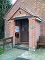 Bishopstone Village hall
 -
 Main Road, Bishopstone
 -
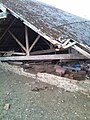 A ruined farm building
 -
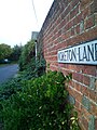 Moreton Lane Street Sign
 -
 Main Road facing West
 -
 Footpath running towards Aylesbury
 -
 The North Bucks way


References
- ^ Neighbourhood Statistics 2001 Census
External links
- Bishopstone Village Website
- The Harrow at Bishopstone (Pub & Restaurant)
- Street List
- v
- t
- e
Aylesbury Vale district
- Aylesbury Constituency
- Buckingham Constituency
(component
areas and hamlets)

(component villages
and hamlets)
- Addington
- Adstock
- Akeley
- Ashendon
- Aston Clinton
- Aston Abbotts
- Aston Sandford
- Barton Hartshorn
- Beachampton
- Berryfields
- Biddlesden
- Bierton
- Boarstall
- Brill
- Broughton Hamlet
- Buckingham Park
- Buckland
- Calvert Green
- Charndon
- Chearsley
- Cheddington
- Chetwode
- Chilton
- Coldharbour
- Creslow
- Cublington
- Cuddington
- Dinton-with-Ford and Upton
- Dorton
- Drayton Beauchamp
- Drayton Parslow
- Dunton
- East Claydon
- Edgcott
- Edlesborough
- Fleet Marston
- Foscott
- Gawcott with Lenborough
- Granborough
- Great Brickhill
- Great Horwood
- Grendon Underwood
- Haddenham
- Halton
- Hardwick
- Hillesden
- Hoggeston
- Hogshaw
- Hulcott
- Ickford
- Ivinghoe
- Kingsbrook
- Kingsey
- Kingswood
- Leckhampstead
- Lillingstone Dayrell with Luffield Abbey
- Lillingstone Lovell
- Little Horwood
- Long Crendon
- Ludgershall
- Maids Moreton
- Marsh Gibbon
- Marsworth
- Mentmore
- Middle Claydon
- Mursley
- Nash
- Nether Winchendon
- Newton Longville
- North Marston
- Oakley
- Oving
- Padbury
- Pitchcott
- Pitstone
- Poundon
- Preston Bissett
- Quainton
- Quarrendon
- Radclive-cum-Chackmore
- Shabbington
- Shalstone
- Slapton
- Soulbury
- Steeple Claydon
- Stewkley
- Stoke Hammond
- Stoke Mandeville
- Stone with Bishopstone and Hartwell
- Bishopstone
- Hartwell
- Lower Hartwell
- Sedrup
- Stone
- Stowe
- Swanbourne
- Thornborough
- Thornton
- Tingewick
- Turweston
- Twyford
- Upper Winchendon
- Waddesdon
- Water Stratford
- Watermead
- Weedon
- Weedon
- Westbury
- Westcott
- Weston Turville
- Whaddon
- Whitchurch
- Wing
- Wingrave
- Woodham
- Worminghall
- Wotton Underwood
and boroughs
constituencies
- Buckinghamshire County Constituency
- Wendover Constituency


