Bagwai
LGA and town in Kano State, Nigeria
Bagwai Garin Danmadami | |
|---|---|
LGA and town | |
| Nickname: BGW | |
| 12°09′28″N 8°08′09″E / 12.15778°N 8.13583°E / 12.15778; 8.13583 | |
| Country |  Nigeria Nigeria |
| State | Kano State |
| Area | |
| • Total | 405 km2 (156 sq mi) |
| Population (2006 census) | |
| • Total | 162,847 |
| Time zone | UTC+1 (WAT) |
| 3-digit postal code prefix | 701 |
| ISO 3166 code | NG.KN.BA |
 | |
Bagwai is a local government area in Kano State, Nigeria. Its headquarters is in the town of Bagwai.
It has an area of 405 km2 and had a population of 162,847 in the 2006 census. The third biggest dam in Kano State Watari Dam is located in Bagwai. The postal code of the area is 701.[1]


Wards
There are ten wards in Bagwai local government:
- Bagwai
- Dangada
- Gadanya
- Gogori
- Kiyawa
- Kwajale
- Rimin Dako
- Romo
- Sare-Sare
- Warure
- Tsakuwa
- Wuro Bagga
-
 Boat at Watari dam Bagwai
 -
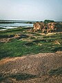 Watari Dam
 -


References
- ^ "Post Offices- with map of LGA". NIPOST. Archived from the original on 7 October 2009. Retrieved 2009-10-20.
- v
- t
- e
Kano StateState capital: Kano
- Ajingi
- Albasu
- Bagwai
- Bebeji
- Bichi
- Bunkure
- Dala
- Dambatta
- Dawakin Kudu
- Dawakin Tofa
- Doguwa
- Fagge
- Gabasawa
- Garko
- Garun Mallam
- Gaya
- Gezawa
- Gwale
- Gwarzo
- Kabo
- Kano Municipal
- Karaye
- Kibiya
- Kiru
- Kumbotso
- Kunchi
- Kura
- Madobi
- Makoda
- Minjibir
- Nasarawa
- Rano
- Rimin Gado
- Rogo
- Shanono
- Sumaila
- Takai
- Tarauni
- Tofa
- Tsanyawa
- Tudun Wada
- Ungogo
- Warawa
- Wudil

 | This Kano State, Nigeria location article is a stub. You can help Wikipedia by expanding it. |
- v
- t
- e


