Al Wahbah crater

Al Wahbah Crater (Arabic: فَوْهَة ٱلْوَعْبَة, romanized: Fawhat al-Waʿbah), also Maqlaʿ Ṭamiyyah (مَقْلَع طَمِيَّة), is a volcanic crater, which is about 250 kilometres (160 miles) away from Ta'if on the western edge of the Harrat Kishb basalt plateau in the Hejazi region of Saudi Arabia (lat. 22.90632, lon. 41.13849).
The Harrat Kishb plateau[1][2] contains many volcanic cones. It is 250 m (820 ft) deep and 2 km (1.2 mi) in diameter. The bottom of the crater is covered with white sodium phosphate crystals.
Origin
While it was thought for some time that the crater was formed by a meteorite, as its appearance resembles that of the Barringer Crater, with its circular form and high sides, it is now commonly accepted by geologists that the crater is a maar crater, and was formed by volcanic activity in the form of an underground phreatic eruption – a massive steam explosion generated by molten basaltic magma coming into contact with subterranean water.[3]
Vegetation
The remains of date palm plantations can be found halfway down the side of the crater, but they are disused. There are springs near the plantations. It is easy to climb down from the rim to the bottom of the crater there from the north side on a prepared path, although most of the circumference has steep unclimbable cliffs. At the top of the path is a stone hut which contains rubbish and debris, and some suitable places for camping, although there are better places to camp to the south (see below). In the north of the Wahbah Crater, there is some vegetation located.[citation needed]
Tourism
It takes a person 45–60 minutes to go to the bottom of the crater. This crater is very slippery and it is hard for people to come up to the surface. To climb back up takes approx 60–90 minutes. There is some mobile phone signal within the crater, and the site receives very few visitors, even over weekends. As of April 2017, there has been upgrades to the park. A stone wall has been erected about 1/4 to 1/3 of the crater rim from the northwest to southwest. There is a mosque at the end of the entrance road. There are also upgraded picnic shelters around the rim.[citation needed]
-
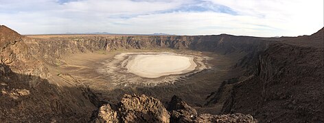 Panorama
 -
 Palm trees
 -
 Centre of the crater


See also
 Saudi Arabia portal

- List of volcanoes in Saudi Arabia
- Sarat Mountains
- Hijaz Mountains
- Harrat Rahat
- Hijaz Mountains
References
External links
- Mekshat
- Global Volcanism Program Archived 2013-02-20 at the Wayback Machine
- 3D model of the crater
22°54′0″N 41°8′20″E / 22.90000°N 41.13889°E / 22.90000; 41.13889
- v
- t
- e
Hills and mountains on the Arabian Peninsula


Note: Mountains are sorted in alphabetical order, unless where it concerns ranges. The highest confirmed mountains in each country are indicated with 'HP', and those with the highest peak are indicated with 'HP', bearing in mind that in the UAE, the highest mountain and the mountain with the highest peak are different. Outcrops are indicated with 'OC', and outliers with 'OL', and anticlines with 'AC'. Volcanoes are indicated with 'V', volcanic craters with 'VC', lava fields with 'LF', and volcanic fields with 'VF'.
Other notes:
- ^ Shared with the UAE
- ^ Also regarded as being of the Western Hajar
- ^ Also regarded as being of the Western Hajar
- ^ Shared with the UAE
- ^ Shared with the UAE
- ^ Sensu lato, shared with Yemen
- ^ Shared with Yemen
- ^ Sensu lato
- ^ Sensu lato
- ^ Shared with Oman
- ^ Shared with Oman
- ^ Highest mountain in the UAE, but the peak is in Oman
- ^ Due to the peak of Jebel Jais being in Oman, this mountain has the highest confirmed peak in the UAE
- ^ Shared with Oman
- ^ Shared with Oman
- ^ Shared with Saudi Arabia
- ^ Highest confirmed peak in the Arabian Peninsula


