26th parallel north
Circle of latitude

26°
class=notpageimage|
26th parallel northMap all coordinates using OpenStreetMap
Download coordinates as:
- KML
- GPX (all coordinates)
- GPX (primary coordinates)
- GPX (secondary coordinates)
The 26th parallel north is a circle of latitude that is 26 degrees north of the Earth's equatorial plane. It crosses Africa, Asia, the Indian Ocean, the Pacific Ocean, North America and the Atlantic Ocean.
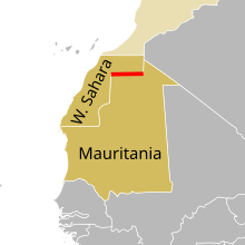
A section of the border between Western Sahara and Mauritania is defined by the parallel.[1]
It is the most populous parallel on Earth, being home to between 247.2 million and 248.0 million people as of 2019.[2]
At this latitude the sun is visible for 13 hours, 46 minutes during the summer solstice and 10 hours, 31 minutes during the winter solstice. The sun is at 40.17 degrees in the sky during the winter solstice and 87.83 degrees in the sky during the summer solstice.[3]
Around the world
Starting at the Prime Meridian and heading eastwards, the parallel 26° north passes through:
Co-ordinates Country, territory or sea Notes 26°0′N 0°0′E / 26.000°N 0.000°E / 26.000; 0.000 (Prime Meridian)  Algeria
 26°0′N 9°32′E / 26.000°N 9.533°E / 26.000; 9.533 (Libya)  Libya
Libya 26°0′N 25°0′E / 26.000°N 25.000°E / 26.000; 25.000 (Egypt)  Egypt
Egypt 26°0′N 34°20′E / 26.000°N 34.333°E / 26.000; 34.333 (Red Sea) Red Sea 26°0′N 36°42′E / 26.000°N 36.700°E / 26.000; 36.700 (Saudi Arabia)  Saudi Arabia
 26°0′N 50°4′E / 26.000°N 50.067°E / 26.000; 50.067 (Persian Gulf) Persian Gulf Gulf of Bahrain 26°0′N 50°28′E / 26.000°N 50.467°E / 26.000; 50.467 (Bahrain)  Bahrain
 26°0′N 50°38′E / 26.000°N 50.633°E / 26.000; 50.633 (Persian Gulf) Persian Gulf Gulf of Bahrain 26°0′N 51°2′E / 26.000°N 51.033°E / 26.000; 51.033 (Bahrain)  Qatar
Qatar 26°0′N 51°24′E / 26.000°N 51.400°E / 26.000; 51.400 (Persian Gulf) Persian Gulf Passing between the islands of Bani Forur and Sirri,  Iran
Iran
Passing between the Tunb Islands and the island of Abu Musa, controlled by Iran but claimed by  United Arab Emirates
 26°0′N 56°4′E / 26.000°N 56.067°E / 26.000; 56.067 (United Arab Emirates) United Arab Emirates 26°0′N 56°10′E / 26.000°N 56.167°E / 26.000; 56.167 (Oman)  Oman
Oman Musandam peninsula 26°0′N 56°25′E / 26.000°N 56.417°E / 26.000; 56.417 (Indian Ocean) Indian Ocean Gulf of Oman 26°0′N 57°14′E / 26.000°N 57.233°E / 26.000; 57.233 (Iran) Iran 26°0′N 61°48′E / 26.000°N 61.800°E / 26.000; 61.800 (Pakistan)  Pakistan
 Balochistan
Sindh26°0′N 70°5′E / 26.000°N 70.083°E / 26.000; 70.083 (India)  India
India Rajasthan
Madhya Pradesh
Uttar Pradesh
Bihar
West Bengal26°0′N 88°9′E / 26.000°N 88.150°E / 26.000; 88.150 (Bangladesh)  Bangladesh
 26°0′N 89°32′E / 26.000°N 89.533°E / 26.000; 89.533 (India) India West Bengal – for about 4 km 26°0′N 89°35′E / 26.000°N 89.583°E / 26.000; 89.583 (Bangladesh) Bangladesh 26°0′N 89°49′E / 26.000°N 89.817°E / 26.000; 89.817 (India) India Assam
Meghalaya
Assam
Nagaland26°0′N 95°8′E / 26.000°N 95.133°E / 26.000; 95.133 (Myanmar)  Myanmar (Burma)
 26°0′N 98°36′E / 26.000°N 98.600°E / 26.000; 98.600 (China)  People's Republic of China
 Yunnan
Guizhou
Guangxi
Hunan (passing between Guangxi and Hunan several times)
Jiangxi
Fujian — passing just south of Fuzhou26°0′N 119°43′E / 26.000°N 119.717°E / 26.000; 119.717 (East China Sea) East China Sea Passing just north of the disputed Senkaku Islands 26°0′N 127°40′E / 26.000°N 127.667°E / 26.000; 127.667 (Pacific Ocean) Pacific Ocean Passing just south of the island of Okinawa,  Japan
Japan
Passing just north of the island of Kita Daito, Japan
Passing just south of Lisianski Island, Hawaii, United States
Passing just north of the atoll of Laysan, Hawaii, United States 26°0′N 112°12′W / 26.000°N 112.200°W / 26.000; -112.200 (Mexico)  Mexico
 Baja California Sur 26°0′N 111°20′W / 26.000°N 111.333°W / 26.000; -111.333 (Gulf of California) Gulf of California 26°0′N 111°10′W / 26.000°N 111.167°W / 26.000; -111.167 (Mexico) Mexico Baja California Sur – Isla Carmen 26°0′N 111°5′W / 26.000°N 111.083°W / 26.000; -111.083 (Gulf of California) Gulf of California 26°0′N 109°26′W / 26.000°N 109.433°W / 26.000; -109.433 (Mexico) Mexico Sinaloa
Chihuahua
Durango
Coahuila
Nuevo León
Tamaulipas - passing just south of Reynosa26°0′N 97°39′W / 26.000°N 97.650°W / 26.000; -97.650 (United States) United States Texas - Passing through Brownsville 26°0′N 97°9′W / 26.000°N 97.150°W / 26.000; -97.150 (Gulf of Mexico) Gulf of Mexico 26°0′N 81°45′W / 26.000°N 81.750°W / 26.000; -81.750 (United States) United States Florida – passing through Hollywood (between Fort Lauderdale and Miami) 26°0′N 80°7′W / 26.000°N 80.117°W / 26.000; -80.117 (Atlantic Ocean) Atlantic Ocean 26°0′N 77°24′W / 26.000°N 77.400°W / 26.000; -77.400 (Bahamas)  Bahamas
 Island of Great Abaco 26°0′N 77°11′W / 26.000°N 77.183°W / 26.000; -77.183 (Atlantic Ocean) Atlantic Ocean 26°0′N 14°30′W / 26.000°N 14.500°W / 26.000; -14.500 (Western Sahara) Western Sahara Claimed by  Morocco and the
  Sahrawi Arab Democratic Republic
 26°0′N 12°0′W / 26.000°N 12.000°W / 26.000; -12.000 (Western Sahara / Mauritania border) Western Sahara /  Mauritania border
 26°0′N 8°40′W / 26.000°N 8.667°W / 26.000; -8.667 (Mauritania) Mauritania 26°0′N 6°26′W / 26.000°N 6.433°W / 26.000; -6.433 (Mauritania) Algeria


See also
References
- ^ Brownlie, Ian (1979). African Boundaries: A Legal and Diplomatic Encyclopedia. Institute for International Affairs, Hurst and Co. pp. 437–44.
- ^ "World Population Distribution by Latitude and Longitude". Engaging Data. 2019-03-18. Retrieved 2020-08-05.
- ^ "Duration of Daylight/Darkness Table for One Year". U.S. Naval Observatory. 2019-09-24. Archived from the original on 2019-10-12. Retrieved 2021-03-10.
- v
- t
- e
Circles of latitude / meridians

Equator
Tropic of Cancer
Tropic of Capricorn
Arctic Circle
Antarctic Circle
Equator
Tropic of Cancer
Tropic of Capricorn
Arctic Circle
Antarctic Circle
90°
180°
90°
180°
45°
45°
45x90
45x90
45x90
45x90


