Toledo District
| Toledo | |
|---|---|
 | |
| Daten | |
| Hauptstadt | Punta Gorda |
| Einwohnerzahl | 28.000 |
| Fläche | 4.413 km² |
| Bevölkerungsdichte | 6 Ew./km² |
| ISO 3166-2 | BZ-TOL |
 | |
 | |
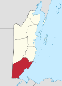
Toledo ist die südlichste Bezirk (District) in Belize (Mittelamerika) und hat auf einer Fläche von 4413 km² rund 28.000 Einwohner (Berechnung 2006).
Die Bezirkshauptstadt von Toledo ist Punta Gorda.
In Toledo befinden sich die historischen Maya-Ruinen von Lubaantun, Nim Li Punit und Uxbenka. Weitere Orte in Toledo sind: San Antonio (größte Siedlung der Mopan-Maya), Monkey River Town, Toledo Settlement und die Dörfer San Pedro Columbia und Silver Creek.
Siehe auch
- Maya Golden Landscape
Weblinks
- Karte von Toledo

Distrikte in Belize
Belize | Cayo | Corozal | Orange Walk | Stann Creek | Toledo
16.099722222222-88.933333333333Koordinaten: 16° 6′ N, 88° 56′ W


